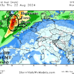
Remains of Ernesto Gust Across Ireland/U.K. Thursday
08/18/2024, 12:02 pm EDTEastern Europe Heatwave Ahead
08/21/2024, 5:22 am EDT
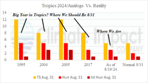
Fig. 1: A comparison between the analog years used to generate the 2024 North Atlantic seasonal activity forecast for tropical cyclones and their 8/31 activity level compared to 2024 and the 30-year normal (for 8/31).
Discussion: Beryl, Debby, and Ernesto have been impressive early season tropical cyclones. Each, an over-achiever, considering the general less than spectacular tropical environment to form (strong trade winds/Saharan Dust). So far, 5 tropical storms, 3 hurricanes, and 1 intense hurricane have formed in 2024 (Fig. 1). The amount is slightly above normal for the date. However, unfolding (and likely to continue) is the seasonal activity amount lagging well behind the analog years used to generate the 2024 tropical cyclone season forecast. Based on operational forecast models, the current 2024 activity could remain unchanged through 8/31. In fact, if no additional tropical cyclone activity occurs by 8/31 the amount will match the 30-year normal. During the analog years, the average amount of activity on 8/31 was 10 storms, 4/5 hurricanes, and 2 intense hurricanes. After 8/31, the analog years produced, on average, 9.5 tropical storms, 6.5 hurricanes, and 4.0 intense hurricanes. Based on the analog years and current activity, seasonal activity for 2024 COULD BE as low as 15 storms, 10 hurricanes, and 5 intense hurricanes. NOAA, Colorado State University, Tropical Storm Risk U.K., and Climate Impact Company are not dropping their very active seasonal forecasts as of early August. A special early September update is possible, especially given the anticipated quiet last third of August.