Emerging Hot and Dry Weather across Canada Leads to Drought Risk
07/19/2024, 10:12 am EDTExtreme Heat ALERT for Late July Great Plains!
07/22/2024, 3:05 pm EDTHeadline: When will the North Atlantic tropics turn dangerously active? Mid-August! Florida a prime U.S. target last 1/3 of August.
Charts of the day: The SSTA in the North Atlantic TC basins.
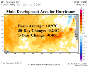
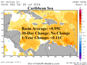
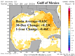
Discussion: The main development region (MDR) for North Atlantic hurricanes maintains a robust basin average SSTA of +0.97C. This value is extremely warm. Rarely does the MDR reach SSTA of +1.0C. The 30-day change is slightly cooler due to an increase in trade winds and recent evolution of Sahara Dust which can block warming sunlight. While extremely warm, the MDR is 0.40C cooler than last year. In the Caribbean Sea, the SSTA remains a robust +0.95C which has not changed from 30 days ago. The SSTA is slightly warmer than last year. The Gulf of Mexico has warmed slightly (+0.23C) during the past 30 days to +0.63C which is moderately warm but somewhat cooler than +1.09C at this time last year.
Week-2 Valid July 28-August 3, 2024 (previous right): ALL CLEAR into early August.
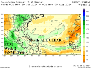
Discussion: Suppressed tropical cyclone activity due to the suffocating influence on low-level atmosphere humidity by Saharan Dust and high-level wind shear continues into early August.
Week 3 Valid August 4-10, 2024: Tropical waves emerging.
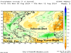
Discussion: The Saharan Dust remains an issue during the first third of August. However, tropical waves are emerging with intensity in the outer tropics although weakening once reaching the western half of the North Atlantic basin.
Week 4 Valid August 11-17, 2024: Tropical cyclones begin, Caribbean Sea targeted.
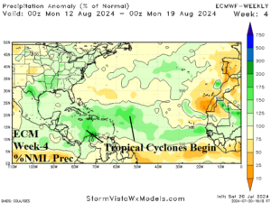
Discussion: Tropical cyclone activity begins in earnest during mid-August with the Caribbean Sea a primary target.
Week 5 Valid August 18-24, 2024: Impacts of tropical cyclones on the U.S. begin.
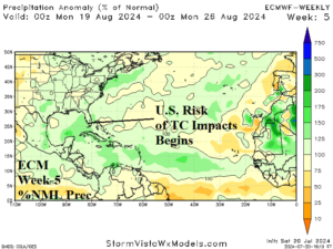
Discussion: Tropical cyclone activity begins to have impacts on the U.S. Coast just after mid-August with Florida the primary target.
Week 6 Valid August 25-31, 2024: Florida remains a primary target.
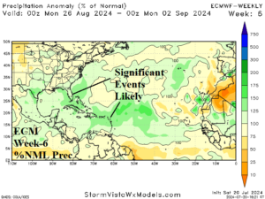
Discussion: Tropical cyclone activity shifts slightly north, toward the subtropics, with trajectories into the Northern Caribbean Islands and Florida.