July 2025 ENSO Outlook: Making the case for weak La Nina in quarter 4/2025.
07/24/2025, 5:23 am EDT![]()
July 2025 Climate Impact Company ENSO, IOD, PDO, and AMO Analog Forecasts
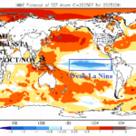
Highlight: La Nina risk to close 2025 increases, classic -PDO generating, North Atlantic basin to stay warm, and weak -IOD possible next 1-3 months.
Executive summary: To help generate new season 1-4 ahead global climate forecasts, a constructed analog projection (through 2027) for ENSO, PDO, AMO, and IOD is revealed. The ENSO outlook indicates weak La Nina potential for Q4/2025 coupled with -IOD which supports wet Australia climate. The tendency of ENSO toward weak La Nina increases risk of significant tropical cyclone activity in the North Atlantic basin during AUG/SEP/OCT. The longest -PDO on record will continue possibly changing character to cooler Northeast Pacific SSTA (which promotes La Nina). The AMO regime stays warm through 2027.
Discussion: To generate the ENSO constructed analog (CA) forecast, a 5-year retrogression is used. The 5-year pattern identifies the El Nino spike during year 3-4, current neutral ENSO, and tendency for weak La Nina early in the period (Fig. 1). Three analog years during the modern climate era (1995-present) are selected to project the 2025-27 ENSO phase. The takeaway is that based on historical precedent there is a 2:1 chance that neutral ENSO to a weak La Nina dominates the next 2+ years. Current climate diagnostics (cooling Nino34 sea surface temperature anomalies [SSTA] and subsurface equatorial East Pacific) support the weak La Nina solution for later 2025.
In one of the most dramatic examples of climate change as applied to SSTA regimes, the North Pacific has shifted historically warm off the East Asia Coast to just east of the Dateline while the Northeast Pacific is closer to normal. The difference in SSTA patterns has spawned the longest and most intense -PDO regime on record. Historically, -PDO is present when the Northeast Pacific is cool. However, during 2020-25, the Northeast Pacific has been “less warm” than waters to the west leading to a different climate compared to historical -PDO. Interestingly, during recent weeks, the old style -PDO appears to be developing as waters off the U.S. West Coast have shifted much cooler. The traditional -PDO regime which appears to be developing now increases the risk of La Nina returning as the cold California Current funnels cooler water toward the tropics. The CA forecast maintains the cool phase well into 2027 as the longest -PDO on record continues (Fig. 2).
While the North Pacific basin has warmed dramatically during this decade, the already warmer than normal North Atlantic basin has nearly doubled strength during recent years. The long-term cycle of the Atlantic multi-decadal oscillation (+AMO) began in the late 1990’s. Typically, the long-term cycle lasts 2-4 decades. Currently, the +AMO cycle is midway through the 4th decade (Fig. 3). The prohibitive warmth of the past 2-3 years has eased. Potentially, the long-term +AMO is entering a moderate warm signature similar with 2010-17 versus the warmer recent scenario. The takeaway is that +AMO continues and there is no sign of a change in the long-term cycle. The leading climate influence of +AMO, among many, is a warming influence on the East U.S. and Europe, especially during winter, and increased numbers and intensity of tropical cyclones.
The daily Indian Ocean Dipole (IOD) shifted sharply to negative phase during recent days. Dynamic models are generally supportive of a weak -IOD to finish 2025. The CA forecast indicates a brief and weak -IOD which peaks during November (Fig. 4). The combination of -IOD and La Nina tendency mentioned earlier is a prohibitive wet climate producer for Australia. Interestingly, the CA forecast projects cool and warm spike potential occurring simultaneously late next year and again late in 2027. The takeaway for IOD is likely cool phase, stronger than the analog forecast for later this year followed by a low confidence neutral outlook for 2026-27.
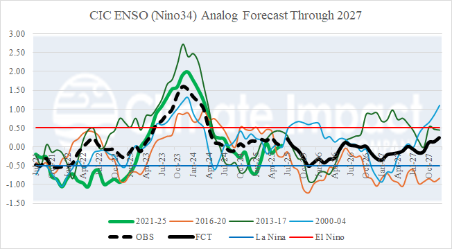
Fig. 1: The Climate Impact Company ENSO phase (using Nino34 SSTA) analog forecast through 2027.
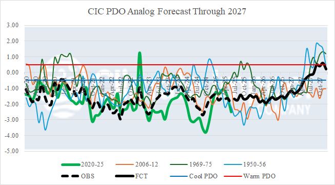
Fig. 2: The Climate Impact Company Pacific decadal oscillation (PDO) analog forecast through 2027.
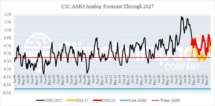
Fig. 3: The Climate Impact Company Atlantic multi-decadal oscillation (AMO) analog forecast through 2027.
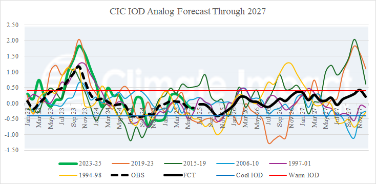
Fig. 4: The Climate Impact Company Indian Ocean Dipole (IOD) analog forecast through 2027.