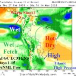
Strong Subtropical High Pressure = Hot/Dry Brazil and Australia
02/27/2025, 8:43 am EST
La Nina Modoki Developing; El Nino to follow?
03/02/2025, 2:11 pm EST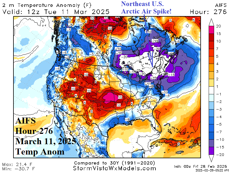
Highlight: Powerful Madden Julian oscillation episode weakens and releases heat poleward into upper atmosphere to warm the stratosphere. Result? Late season cold spikes ahead for the U.S. while La Nina weakens rapidly.
Discussion: Later next week stratospheric warming organizes over Siberia and shifts to the polar region in the 11-15-day period (Fig. 1). Winter 2024-25 has featured a colder than normal stratosphere with two brief notable exceptions just after mid-January and just-after mid-February when the stratosphere warmed across Canada and each episode caused an arctic outbreak into the U.S. During each event, the global atmospheric angular momentum (GLAAM) slowed down as the deep polar vortex formed in weakened mid-latitude westerlies (Fig. 2). The 15-day GLAAM forecast reveals another slowdown of the mid-latitude westerlies, rivaling the just-after mid-January event. However, forecast models are not identifying an organized “polar vortex” episode in the troposphere, at least not yet.
What is likely, and indicated by AIFS, are arctic air spikes that emerge in Canada and pulse into the U.S. not lasting very long but are exceptionally cold. The first of these cold spikes is centered on March 11th into the Northeast U.S. (Fig. 3) where AIFS produces daytime temperatures in the mid 20’s in Boston, low 30’s in NYC, and mid 30’s in Philadelphia. The arctic air is limited to this sector. Night temperatures fall to near zero over northern New England, teens in Boston, and low 20’s as far south as Philadelphia. The event is only a couple of days long with rapid warming to follow. This is the only arctic spike indicated so far.
Markets should watch physics-based models (GFS and ECM) to produce similar cold spikes to validate the AI model. However, the GLAAM slowdown supports some sort of cold surprise not yet indicated by operational models possibly because the cold event is brief as indicated by AIFS.
What caused this stratospheric warming is important. The best estimate is a heat release from a long duration convection phase of the Madden Julian oscillation during the past several weeks into the upper atmosphere and transported upward into the polar stratosphere via a Rossby Wave. That explanation is proposed due to the reaction of the tropical oceans left behind by the weakening MJO event. For example, in the Nino3 SSTA region the ocean surface has warmed >1C during the past 30 days (Fig. 4) and currently is at +0.46C (Fig. 5) which is near the El Nino threshold. Last we knew, an ongoing La Nina was present and forecast to weaken in 1-3 months. ENSO diagnostics reveal a rapidly changing scenario.
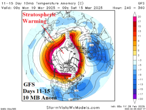
Fig. 1: Stratospheric warming is vividly displayed by GFS in the 11-15-day period.
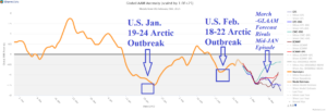
Fig. 2: Global atmospheric angular momentum slows down during polar vortex events as observed in JAN and FEB. 15-day forecasts imply another polar vortex event COULD occur in March.
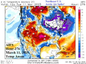
Fig. 3: AIFS generates a chick of arctic air that shifts into the Northeast U.S. during the 11-15-day period.
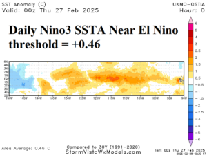
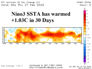
Fig. 4-5: Daily Nino3 (eastern equatorial Pacific Ocean) SSTA observation and the 30-day change.