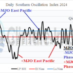
Oceanic AND Atmospheric ENSO is Neutral
05/20/2024, 11:41 am EDT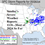
Most Severe Weather Reports of 2024 Was May 26
05/27/2024, 2:19 pm EDT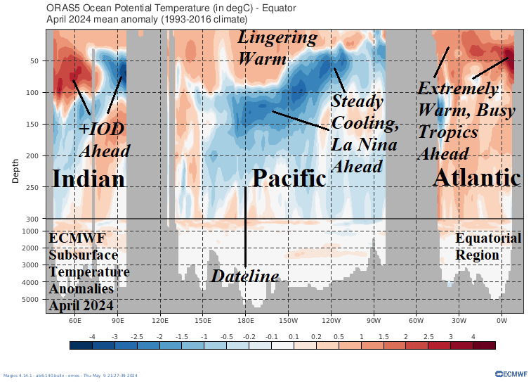
Fig. 1: ECMWF monthly equatorial subsurface oceans potential temperature.
Discussion: The equatorial regions of each ocean basin foreshadow major climate pattern changes ahead if current analysis and trend hold for JUN/JUL/AUG 2024. First, the subsurface equatorial Pacific near and east of the Dateline is cooling. Subsurface warmth leftover from the 2023-24 El Nino lingers near the Dateline but is slowly fading. The cool ocean anomalies have reached the surface off the northwest coast of South America and trade winds should up-well the cooler waters gradually extending westward to initiate La Nina later in the northern hemisphere summer. The warmth across the western Indian Ocean equatorial region vs. the cool subsurface in the eastern tropics signals positive phase of the Indian Ocean dipole (+IOD) ahead. +IOD developing during La Nina is unusual and could slow (or weaken) the cold ENSO development process. +IOD will cause a soaking wet climate across East Tropical Africa to India during the next several months. Finally, the April upper ocean heat in the Atlantic certainly supports the (very) active hurricane season ahead forecasts by Colorado State University, U.K. Tropical Storm Risk, and Climate Impact Company for the 2024 North Atlantic tropical cyclone season. The April 2024 signature is the warmest on record.