News
07/21/2025, 1:36 pm EDT
A map of a weather forecast AI-generated content may be incorrect.

Subsurface Equatorial East Pacific Showing Signs of Cooling

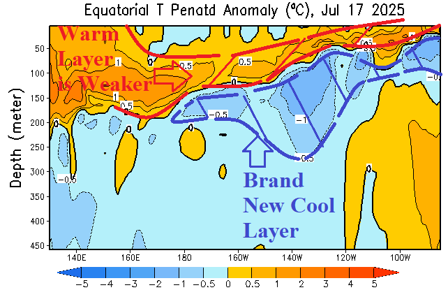
The upper ocean temperature anomaly structure in the eastern equatorial Pacific indicates a new moderately deep cool layer. The warm layer just beneath the surface is beginning to weaken. The long-term ENSO outlook for later in 2025 remains in the neutral phase. However, as observed all of 2025, some models are indicating La Nina development, and a slight cooler trend has developed supportive of the La Nina outlier forecasts.
07/17/2025, 9:18 am EDT
A map of the united states with different colored areas AI-generated content may be incorrect.

New NOAA Long-lead Climate Forecasts Implicate Southeast U.S. for Tropical Cyclone Risk

NOAA/CPC has updated their monthly long-lead probabilistic temperature and precipitation forecasts. Additionally, a new Seasonal Drought Forecast is issued. Of note, is the precipitation outlook for both August and AUG/SEP/OCT. The outlooks indicate a high probability of above normal rainfall in the Southeast U.S. The August probability forecast for above normal rainfall in the Southeast U.S. is exceptionally confident.
07/14/2025, 4:42 am EDT
A map of weather forecast AI-generated content may be incorrect.

Wicked Weather Ahead for Australia

An ambitious convection phase of the Madden Julian oscillation (MJO) is located north of Australia. Meanwhile, a persistent deep upper trough rides across the southern oceans not far from Australia. If the upper trough can entrain at least some of the MJO energy, an amplified trough delivering stormy weather and potential colder temperatures would emerge.