Indian Ocean Dipole Shifts Negative, Albeit Weak
08/27/2024, 2:34 pm EDTBelow Normal Tropical Cyclone Activity for Both North Pacific and North Atlantic
09/13/2024, 11:55 am EDTExecutive summary: Tropical cyclone activity as of September 3, 2024, in the North Atlantic basin is 5 tropical storms, 3 hurricanes, and 1 intense hurricane. The activity level is now below normal for early September. Of interest is the tropical cyclone activity in the West Pacific and East Pacific (basins) are also below normal. A review of the seasonal hurricane activity predictors is mixed with warm SSTA in the main development region (MDR) supportive of hurricane development while fast trade winds suppressing tropical development have been a significant inhibiting factor. Going forward, conditions are likely to improve as tropical Africa is wetter and eliminates the suppressing influence of Saharan dust on tropical cyclone development, trade winds are lighter, a La Nina climate develops, and the dry influence on the North Atlantic tropics of the subsidence phase of the Madden Julian oscillation fades. However, seasonal totals of North Atlantic basin tropical cyclone activity are likely to fall well below the pre-season very buoyant projections. The primary problem has been faster than normal trade winds and unexpected amounts of dry air.
Atlantic Main Development Region (MDR) for hurricanes: The MDR remains warmer than normal (Fig. 1). The western half of the MDR is where the bulk of the anomalous warmth is located. The eastern portion of the MDR has cooled slightly. South of the MDR, considerable upper ocean heat loss has been observed during the summer season. However, within the MDR, hurricane development is favorable Based on SSTA and upper ocean heat.
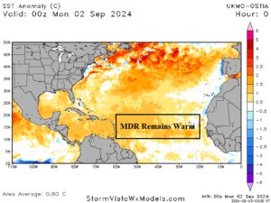
Fig. 1: SSTA across the main development region for hurricanes.
Trade wind speed: Lighter than normal trade winds are favorable for hurricane development. A major issue with lack of deep tropics hurricanes as the climatological peak of season approaches is (much) faster than normal trade winds across the deep tropics in August (Fig. 2).
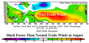
Fig. 2: August 2024 zonal wind speed anomalies across the North Atlantic tropics.
El Nino southern oscillation: ENSO is in neutral phase. The JUN/JUL multivariate ENSO index was -0.7 which is within the La Nina threshold and suggests a La Nina climate was developing ahead of oceanic La Nina onset. The southern oscillation index (SOI) is strongly into the positive phase which is favorable for La Nina development. Subsurface waters in the equatorial Pacific are moderately cool. A trend toward weak La Nina is underway in September. The ENSO contribution to the North Atlantic tropics is marginally supportive as the upper westerly shear is generally below normal.
Sahara dust: The westward expansion of Sahara dust has been an above normal suppressing factor on North Atlantic tropical cyclone activity through the first half of the season. However, the Africa tropics are shifting very wet, and this issue should subside dramatically in September.
Tropical upper tropospheric trough: A high-level trough has developed over the southwest Caribbean Sea during recent days. Usually, well-formed TUTT patterns feature an elongated trough across the Caribbean Sea and northward to the subtropics. The TUTT pattern has not been present this year.
Madden Julian oscillation: Ideally, the MJO location across tropical Africa (phase_1/phase_2) is supportive of North Atlantic tropical cyclone activity. In this condition, the tropical Africa climate is extremely wet and able to emit strong tropical waves into the North Atlantic tropics with above normal potential to become significant tropical cyclones. Although tropical Africa is trending wetter, the MJO location has strengthened in phase_5 which is the Maritime Continent. In this location, MJO influence on the North Atlantic tropics is subsidence which defeats tropical cyclone development.
Quasi-biennial oscillation: The QBO has shifted sharply from strong negative to weak positive phase since early in 2024. The QBO is a less reliable predictor of tropical cyclone activity than observed in the 1950’s to 1980’s. However, presence of the positive phase implies increasing ventilation in the upper atmosphere across the deep tropics which is favorable for hurricane development.