Northern Gulf of Mexico is Cooling off
07/13/2023, 9:50 am EDTDry Soil Moisture Emerging In Australia
07/23/2023, 3:49 pm EDTHighlight: Active MJO develops, should strengthen El Nino. MJO inspires hotter medium-range forecast across U.S. AND cooler East early August.

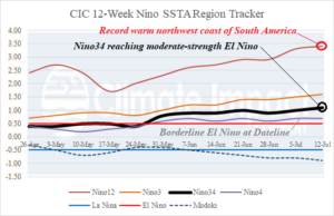
Fig. 1: The Climate Impact Company 12-week SSTA observations reveal emergence of a weak-to-moderate El Nino.
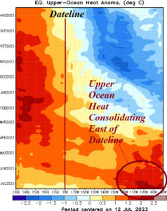
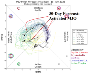
Discussion: The ocean surface off the northwest coast of South America near the equator is record warm for July (Fig. 1). In the east-central equatorial Pacific waters are warming and El Nino reaches moderate strength although near the Dateline, an El Nino signature is barely visible. The upper ocean heat is starting to consolidate in the eastern half of the equatorial Pacific, typical of most well-organized warm ENSO events (Fig. 2). During the past few days, the southern oscillation index (SOI) has shifted back into a weak negative phase. Further negative phase strengthening is expected as the Madden Julian oscillation (MJO) activates and shifts east through the equatorial Pacific over the next 1-2 weeks and farther east across the Atlantic tropics in early August (Fig. 3). The activated MJO/SOI combination should shutdown trade winds in the equatorial Pacific to allow warming of the surface and strengthen El Nino heading into August. The east shifting MJO across the equatorial Pacific dries out South America the remainder of July and causes the hot U.S. pattern to expand. As MJO shifts toward Africa early next week, the East U.S. will cooldown.

Fig. 2: Subsurface upper ocean heat is consolidating in the eastern equatorial Pacific Ocean to the east of the Dateline.

Fig. 3: The Madden Julian oscillation reactivates, shifts across the equatorial Pacific the last third of July, and will strengthen El Nino.
