Polar Ice Cap Continues Well Below Normal
03/01/2024, 1:19 pm ESTSoaking Wet Northeast U.S. Soils
03/05/2024, 5:51 am ESTHighlight: Storminess to shift into the East; medium range stays warm.
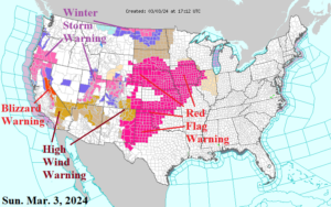
Fig. 1: The latest NOAA/NWS weather watch, warning, and advisory areas.
Discussion: An impressive Upper Midwest U.S. storm (990 MB) is causing a plethora of weather hazards this afternoon including high wind spawning a Red Flag Warning across most of the Great Plains, additional high wind across the Southwest U.S., and many areas of heavy snow (with wind) including North Dakota, California, and the eastern Great Basin to central Rockies (Fig. 1). Prohibitive snows continue across the Sierra Nevada where a Blizzard Warning is in effect. The week ahead indicates the storminess on the West Coast slowly eases and becomes focused on the eastern half of the nation. Excessive rainfall causing flooding is likely tomorrow and Tuesday from Louisiana to Alabama shifting to southern New England on Wednesday and returning to the Mid-south States Thursday (Fig. 2). The warm pattern is relentless. Combining the GFS and ECM yields more prohibitive warmth across much of North America in the medium range (Fig. 3-4). There are signs of cooler weather in 15 days. The U.S. gas population weight HDD forecast trend is much warmer since Friday (Fig. 5).
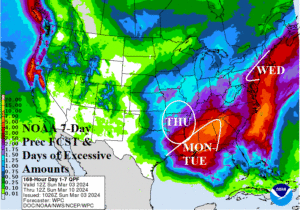
Fig. 2: The NOAA/WPC quantitative precipitation forecasts for the next 7 days highlight areas of excessive precipitation and flood risk.
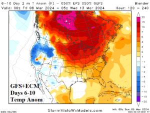
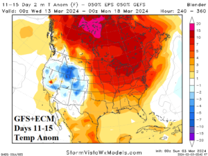
Fig. 3-4: Combining GFS and ECM equally to produce the medium-range temperature anomaly forecast.
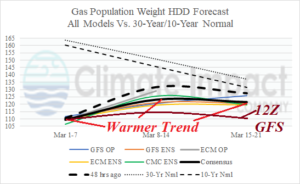
Fig. 5: The U.S. gas population weight HDD forecast using all models and their consensus and compared with 48 hours ago plus the 30-year/10-year normal.
