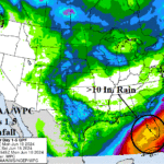
Extreme Rains Over Southern Florida This Week
06/10/2024, 5:45 am EDT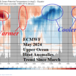
Atlantic Upper Ocean Heat is Becoming Less Impressive
06/12/2024, 11:13 am EDT
Highlight: System to watch in East Gulf; Extreme heat ahead for Midwest.
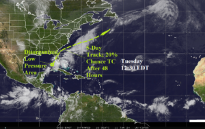
Fig. 1: Satellite view of the North Atlantic basin.
Discussion: NOAA/NHC identified an area of disorganized low pressure southwest of Tampa, FL earlier today forecast to drift northeastward, crossing the Florida Peninsula, and re-emerging off the northeast Florida Coast within 36 hours (Fig. 1). Strengthening prior to striking the Florida West Coast is unlikely due to upper shear although SST is a buoyant 86F and supports organization. The Gulf Stream is 85F off the Georgia Coast where NOAA/NHC indicates 20% risk of tropical cyclone formation. The CIC 5-day forecast track is based on the 12Z GFS which takes this system northeastward and out to sea. The 12Z GFS 48-hour rainfall forecast produces up to 7 inches of rain on the southwest coast of Florida and near 5 in. of rain near Cape Canaveral (Fig. 2).
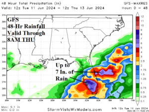
Fig. 2: The 12Z GFS 48-hour rainfall forecast.
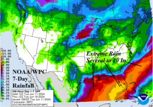
Fig. 3: The NOAA day-7 extreme heat risk outlook valid next Monday.
The “experimental” extreme heat risk forecast from NOAA indicates that next Monday has a risk of extreme heat in the Midwest U.S. (Fig. 3). The midday 12Z GFS indicated an arc of heat from the Southwest to the Upper Midwest to the Northeast States in the medium-range while the Gulf States are rain-cooled (Fig. 4-5).

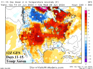
Fig. 4-5: The 12Z GFS medium-range temperature anomaly forecast.
| CDD EIA End Date | Forecast | 12-Hour Change | 24-Hour Change | 30-Year Normal | 10-Year Normal |
| 6/13 | 55.2 | +0.3 | +0.6 | 51.3 | 55.6 |
| 6/20 | 70.6 | -2.3 | -2.5 | 58.8 | 63.3 |
| 6/27 | 94.5 | +7.1 | +7.9 | 66.4 | 71.1 |
Table 1: The 12Z GFS U.S. population weight CDD forecast compared to 12 and 24 hours ago.