Hot Weather Causes Expanding Drought Risk in the U.S.
07/14/2024, 3:38 pm EDTSoutheast Europe/Black Sea Region Drought Continues
07/17/2024, 8:31 am EDTDiscussion: During the past few weeks, Saharan Dust propelled west and southwestward from Northwest Africa by easterly trade winds has increased. Visible satellite images from earlier today easily identify the dust clouds as light gray east of the Caribbean Sea (Fig. 1). The dust clouds extend westward across the Caribbean Sea with increasing intensity during the next couple weeks. The recent axis of strongest trade winds has up-welled some cooler water in the North Atlantic subtropics as identified by the 30-day SSTA change (Fig. 2). The dust particles (lithometeors) can also help to cool the ocean surface by blocking sunlight. Traders and risk planners are asking whether the lack of tropical cyclone activity over the next 2-3 weeks will cause climate forecasters to ease back on buoyant hurricane season predictions for 2024 when final updates are issued on August 1st. The accumulated cyclone energy (ACE) index forecast for 2024 is 230-240 which is just beneath the all-time-record set in 2005 (245). In years when ACE index exceeded 200 (1995, 2004, 2005, and 2017) the early season (prior to August 1st) tropical cyclone activity varied from just 1 storm in 2004 to as many as 7 storms and 3 hurricanes in 2005 (Fig. 3). The Saharan Dust issue is common during July. However, trade winds should ease in August and the inhibiting dust feature fades allowing the lack of upper shear and anomalous warm ocean to generate tropical cyclones fast and furiously once we reach the middle third of August.
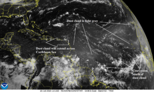
Fig. 1: Visible satellite image from earlier this morning identifying the Sahara dust clouds.
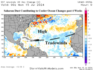
Fig. 2: North Atlantic basin 30-day SSTA change identifies cooling in the subtropical North Atlantic likely due to the combination of up-welling of cooler water by trade winds and possibly blocking of the sun by Saharan Dust.
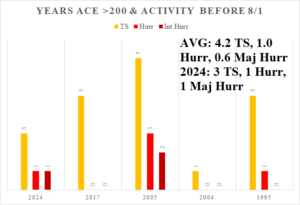
Fig. 3: When ACE index exceeds 200, the early season (prior to Aug. 1) North Atlantic tropical cyclone activity varies.