Rare East-moving Gulf of Mexico Intensifying Hurricane This Week
10/06/2024, 8:47 am EDTSome Wet Weather Ahead in the Black Sea Region
10/08/2024, 4:42 am EDTHighlight: Milton will reach category-5 major hurricane status shortly. Florida landfall adjusted slightly north as a major hurricane.
Discussion: At 11AM EDT, Category-4 Major Hurricane Milton is located at 21.7N/91.7W or about 720 miles southwest of Tampa, FL. Top wind is 155 mph. The threshold of a category-5 major hurricane is 156 mph. Milton is moving east-southeast at 9 mph. Surface pressure has plummeted to 933 MB. NOAA/NHC states that the 85 knot increase in wind speed during the past 24 hours is 3rd fastest behind Wilma (2005) and Felix (2007).
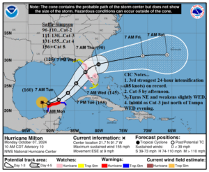
Fig. 1: NOAA/NHC 5-day forecast track for Major Hurricane Milton.
Milton will reach category-5 major hurricane status this afternoon and maintain that strength traveling eastward through tonight. The northeast turning ahead of an approaching upper trough into the Northern Gulf begins later tomorrow. During that time increased upper shear and especially dry air entrainment off the Yucatan will weaken the storm. Milton should increase forward speed ahead of the upper trough on Wednesday making landfall near or just north of Tampa Wednesday evening. As the storm is captured by the upper trough, Milton will become a much larger storm. While Milton loses some intensity during this process, the storm makes landfall as a major hurricane. The landfall location is adjusted slightly farther north as foreshadowed by previous HWRF and HMON hurricane model forecasts. Unfortunately, the adjusted landfall puts Tampa Bay directly in the right front quadrant of the storm where maximum storm surge and wind speed occurs. The Tampa area will be hit hard by this storm. The storm surge will be immense along the entire southwest coast of Florida extending northward to the southern Big Bend area. Salt-water flooding due to storm surge is highest in the Tampa Bay to Port Charlotte Harbor stretch while freshwater flooding from excessive rainfall is strongest from just south of Tampa to just south of Orlando and northward. The heaviest rainfall is forecast for Cape Canaveral to Jacksonville due to longest duration as Milton remains a hurricane once off the Florida East Coast.
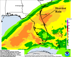
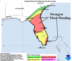
Fig. 2-3: The NOAA/NHC updated rainfall and flash flood risk area forecast.
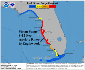

Fig. 4-5: The NOAA/NHC storm surge forecast and aerial coverage of tropical storm force wind.
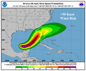
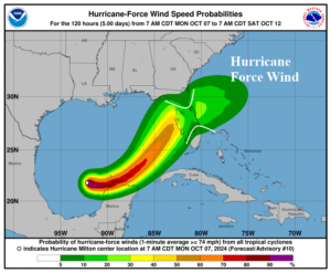
Fig. 6-7: The NOAA/NHC aerial coverage of 50 knot and hurricane force wind.
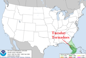
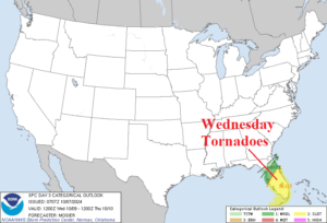
Fig. 6-7: The NOAA/SPC tornado risk area for tomorrow and Wednesday.