Limited Drought Areas in Australia
12/06/2024, 10:36 am ESTCFS V2/ECM Week-4 Forecast Skill Scores Fall Through The Floor
12/10/2024, 4:13 am ESTDiscussion: Early December 2024 was remarkably cold in the East U.S. (Fig. 1). The unexpected chill is due to an unusual weather pattern featuring highly amplified trough and ridge features from Northeast Asia to the East Coast of North America while most of Eurasia has a somewhat benign pattern. The leading climate diagnostic supporting the East U.S. chill is a streak of mid-latitude stratospheric warming (Fig. 2).
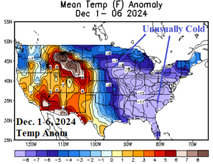
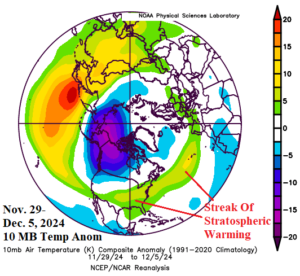
Fig. 1-2: The December 1-6, 2024, U.S. temperature anomalies and an early December streak of stratospheric warming across the East U.S.
As calendar-winter approaches, the stratosphere across North America is cold and supportive of warm surface temperatures. However, as noted last week, a significant stratospheric warming (SW) event is evolving across Eurasia as indicated by the ECM in the 11-15-day period (Fig. 3). Surprisingly, operational models are not indicating arctic air mass development beneath the SW episode through 15 days. An emerging negative phase of the arctic oscillation (-AO), representative of high latitude high pressure blocking and a split of the polar vortex toward middle latitudes and caused by SW episodes is very uncertain in 2 weeks based on the latest forecast from NOAA/CPC (Fig. 4).
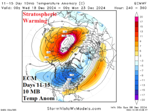
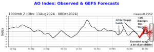
Fig. 3-4: In the 11-15-day period, stratospheric warming is immense over Eurasia. NOAA/CPC indicates a wide variety of forecast solutions of the arctic oscillation in 14 days. -AO is required to present a cold weather risk.
So! The U.S. shifts warmer this week and the warmth may last for a while. ECM continues to indicate a “polar vortex” pattern for the week of Jan. 6-13 (Fig. 5) which may be caused by the downstream effects of the late December SW episode. The PV pattern may also be related to steadily deepening snow over Canada. The deepening snow cover may be causal to a new potential issue in the 11-15-day period forecast by AI models where extreme cold develops across Canada and is leaning toward the Northeast U.S. (Fig. 6).
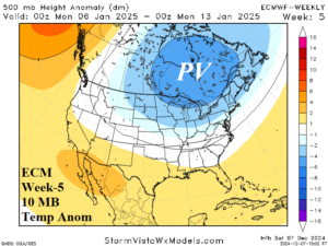
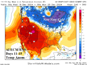
Fig. 5-6: The ECMWF week-5 upper air forecast across North America and the 11-15-day AI version of the ECM ENS temperature anomaly forecast across North America.
