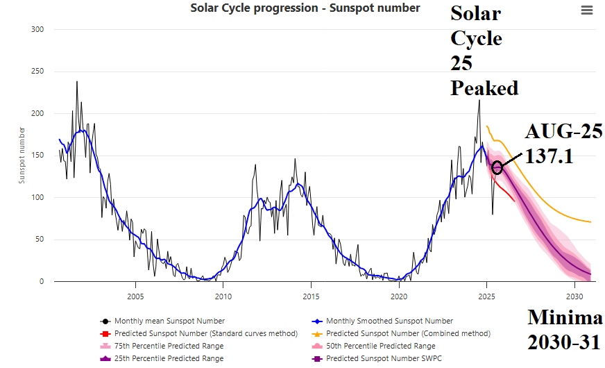
News
07/05/2025, 7:01 am EDT
A map of a storm AI-generated content may be incorrect.

TD 3 Expected to Become a TS; Drift Into South Carolina Tomorrow

Tropical Depression 3 is forecast to strengthen to a tropical storm today, turn north-to-northwestward, and strike the upper coast of South Carolina Sunday morning. Tropical storm conditions are expected on the upper South Carolina Coast/Lower North Carolina Coast late tonight and Sunday. The next storm name is Chantal.
07/01/2025, 5:40 am EDT
A graph of different colored lines AI-generated content may be incorrect.

Equatorial Pacific Upper Ocean Heat Remains Marginally Warm in June

Regarding ENSO, the equatorial Pacific upper ocean heat anomalies stay marginally warm in JUN-25. Implied is no risk of La Nina return, although NCEP CFS V2 is boldly forecasting La Nina for late 2025, with marginal support pointed toward El Nino.
06/30/2025, 1:40 pm EDT
A map of the weather AI-generated content may be incorrect.

12Z GFS Ends (Temporarily) Europe Heatwave in 6-10 Days

The 12Z GFS indicates a cool/wet upper trough moving into West/North Europe to end the recent heatwave and push the heat toward the Black Sea region (Fig. 1). Unfortunately, Western Europe is likely to turn hot again in the 11-15-day period.
06/29/2025, 4:42 pm EDT
A map of the weather AI-generated content may be incorrect.

Cold Air Mass Does Not Reach Brazil Coffee Areas

In South America, a cold burst is forecast early-to-middle week. The air mass is not expected to reach the Brazil coffee growing areas. The coldest morning is Tuesday while Wednesday morning is nearly as cold.