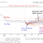
La Nina Strengthens in January; Latest CFS V2 Nino34 Outlook
01/28/2025, 8:55 am EST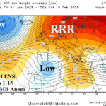
Ridiculously Resilient Europe Ridge
01/31/2025, 9:11 am EST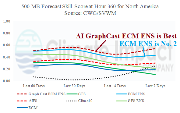
Highlight: Preferring the AI Graph Cast day-15 projection of returning cold to the West/Central U.S.

Fig. 1: The GFS hour-360 forecast of 500 MB height anomalies across the northern hemisphere.
Discussion: At hour-360, operational models indicate sudden stratospheric warming (SSW) shifting into northwestern North America. The GFS is the farthest east with the warming, extending across Canada, similar with the mid-January SSW episode that spawned the January 2025 polar vortex event and Winter Storm “Enzo”. The response of the GFS for 500 MB at hour 360 is mixed showing a ridge bridge over Alaska likely to drive arctic air in the polar region southward into a compensating trough over western North America which is not very impressive considering the SSW event GFS is forecasting (Fig. 1). The Europe 500 MB outlook is mixed with weak trough/ridge forecasts. Interestingly, at hour-360, the forecast skill score for 500 MB heights across North America and Europe for northern hemisphere meteorological winter so far is best using AI Graph Cast ECM ENS or the operational ECM ENS (Fig. 2-3) while GFS OP and (surprisingly) ECM OP is least skillful (except for 10-year climatology). The preferred 360-hour 500 MB anomaly forecast by AI Graph Cast ECM ENS indicates a cold longwave trough (with arctic air) across the West U.S. while an East U.S. ridge is shifting offshore and Northwest Eurasia is beneath an amplified ridge (Fig. 4).

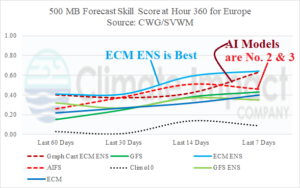
Fig. 2-3: 500 MB height forecast skill at hour 360 for the past 60 days by leading operational and AI predictions.
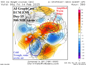
Fig. 4: The AI Graph Cast ECM ENS hour-360 forecast of 500 MB height anomalies across the northern hemisphere.