Neutral ENSO Here to Stay in June
06/04/2024, 2:32 pm EDTDramatic and Different Europe/Russia Spring 2024 Climate
06/10/2024, 5:44 am EDT 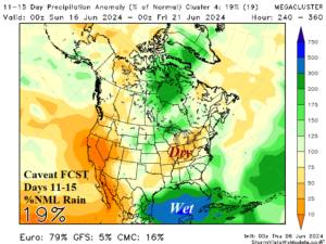
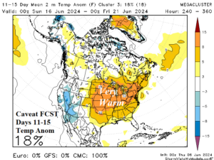
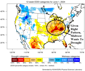
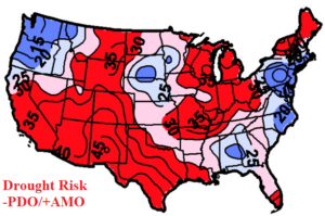
Fig. 1-4: Mega-cluster ensemble “caveat” forecast for 11-15 days (upper), evaporative drought demand index, and -PDO/+AMO summer drought risk (lower).
Discussion: The 2024 North Atlantic basin tropical cyclone season is forecast to potentially be the most active on record given the unusually warm North Atlantic Ocean surface and anticipated evolving La Nina climate. Given this scenario, concern is increasing regarding a wet climate (due to tropical activity) in the Gulf of Mexico and the latent heat release of that convective rain northward to cause the atmosphere to warm and high pressure to form. This scenario is identified in the “caveat” forecast by the mega-cluster ensemble in the 11-15-day period. Note that beneath the high-pressure area is a dry and very warm pattern across the Midwest U.S. (Fig. 1-2). This scenario could become common once we are well into the tropical cyclone season. According to the evaporative drought demand index (EDDI), the Midwest States are very susceptible to developing dry-to-drought conditions if the right climate pattern emerges during the summer season (Fig. 3). Keep in mind that currently we’re in a strong cool phase Pacific decadal oscillation (-PDO) and warm phase Atlantic multi-decadal oscillation (+AMO) climate which historically increases summertime drought risk in the Ohio Valley (Fig. 4).
Southwest Russia winter wheat and corn remain at risk of worsening dry soil conditions as 15-day outlooks stress more heat while approaching rains are mostly west and north of these crop areas (Fig. 5-6).
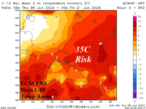
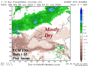
Fig. 5-6: ECM ENS 15-day temperature and precipitation anomaly forecasts for the Black Sea region.