The U.S. Corn Belt Concern
06/06/2024, 8:13 am EDTIncoming Heat for Midwest/Mid-south U.S. Weekend
06/10/2024, 2:12 pm EDT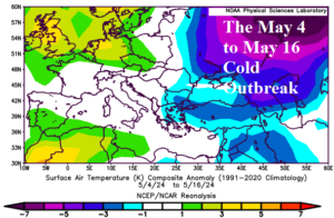
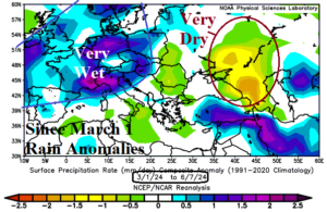
Fig. 1-2: The May 4-16, 2024, cold outbreak across West/Southwest Russia and the dry climate since March 1 in Southwest Russia while Europe is very wet.
Discussion: Europe and Western Russia are the target of extreme weather and climate conditions through the spring season. On May 7, Moscow declared a state of emergency for crop conditions due to damage suffered during many freeze events occurring in early-to-mid May (Fig. 1). Not helping is the long-term lack of precipitation in the Eastern Black Sea region throughout Southwest Russia (Fig. 2). Conversely, much of Europe is soaking wet since March 1.
The latest mega-cluster ensemble “most likely” rainfall forecasts through the next 10 days suggest some much-needed rainfall into Southwest Russia and Southeast Europe in the 5-day outlook (Fig. 3) while the dry zone shifts east of Caspian Sea. In the 6-10-day period, dryness re-emerges across Eastern Europe and into Western Russia although showers may linger in the immediate Black Sea region while more rain convenes across Western Europe (Fig. 4). Although some rain reaches Southwest Russia to the Black Sea region, the 10-day outlook remains somewhat warmer than normal in this region.
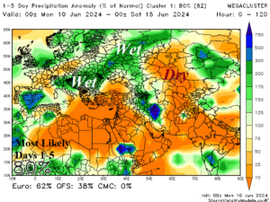
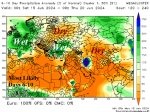
Fig. 3-4: The mega-cluster ensemble “most likely” rainfall forecast across Europe and Western Russia through 10 days.
Precipitation forecasts across the Great Plains vary due to influence of potential heavy tropical rains across the Gulf of Mexico on the U.S. weather pattern. In the 1-5-day period, mega-cluster ensemble “most likely” rainfall anomaly forecasts are confident (80%) projecting dry conditions across most of the U.S. AG Belt (Fig. 5). In the 6-10-day period, wet weather ahead of a Pacific upper trough moves across the west and north Great Plains (Fig. 6). Note the potential tropical system in the Gulf of Mexico. The 11-15-day “most likely” forecast is made with 39% confidence and indicates a broad wet zone across the Gulf of Mexico and Florida with a showery regime along the U.S./Canada border and drier than normal in-between across the southern half of the Great Plains (Fig. 7). Anomalous warmth is projected by mega-cluster ensemble across the Great Plains and eastward in the medium-range.
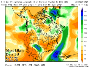
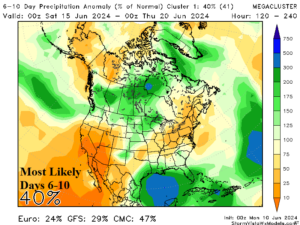
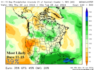
Fig. 5-7: The mega-cluster ensemble “most likely” rainfall forecast across the U.S. through 15 days.