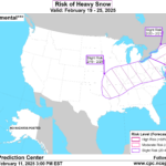
Another Snowstorm Alert for February 19-21; U.S. January 2025 State Climate Rankings
02/11/2025, 4:34 pm EST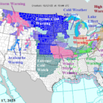
Another Polar Vortex Event This Week in the U.S.
02/17/2025, 7:59 am EST
The 2024-25 ENSO regime has featured evolution of La Nina although occasional surprises remain consistent with the latest the sharp warming of the Nino12 SSTA region off the northwest coast of South America. The daily Nino12 SSTA is +0.88C which is an El Nino-like observation (Fig. 1).
The Nino12 SSTA region warmed by 0.91C during the past 30 days. The Nino34 SSTA, where ENSO phase is measured, has warmed 0.39C during the past 2 weeks to a marginal La Nina measure (-0.49C).
The warming SSTA is related to an eastward surge of Madden Julian oscillation (MJO) convection through the eastern tropical Pacific. In response to the MJO, the southern oscillation index (SOI) flips to negative phase this week.
The warming SSTA brings a rainfall pattern dipole to South America in the latest ECM ENS 15-day forecast (Fig. 2). The warm Nino12 region causes heavy rains over northwest continent and the attendant convective rains are compensated for by subsidence and dry/hot weather across East Brazil. South of the Brazil dryness, heavy rains stretch from Northern Argentina to far Southeast Brazil. Central Argentina is mostly dry and hot.
In the 16-30-day period, GFS ENS indicates the wet northwestern South America/dry East/Southeast Brazil rainfall dipole continues (Fig. 3). However, the northwest South America rains wrap around the Brazil high pressure area and surge into Northern Argentina the first half of March.
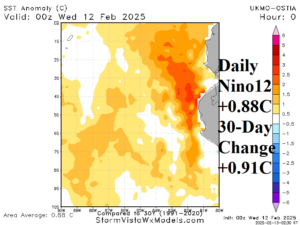
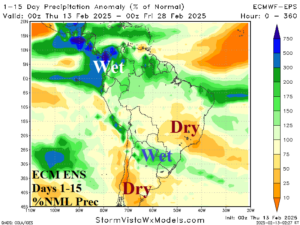
Fig. 1-2: The sudden warming of the Nino12 SSTA region and the impact on northwestern South America rainfall and compensating (rainfall) patterns across the remainder of the continent.
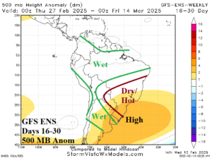
Fig. 3: The GFS ENS 500 MB anomaly pattern forecast for the 16-20-day period and the annotated rainfall regime.