Record Warm Tropical South Atlantic Index/El Nino Inspired Hot/Dry Summer Most of Brazil
03/08/2024, 5:33 am ESTMarch 2024 Global Soil Moisture 3-Month Observation Trend and Forecast
03/13/2024, 3:51 am EDTHighlight: Continuing to forecast La Nina for the second half of 2024.
Executive summary: Marine heat waves continue to gain equal footing to ENSO on climate influence due to the ongoing unprecedented warming of the mid-latitude oceans. Climate Impact Company is tracking 8 large marine heat waves. The 2024 ENSO projection is based on an analog forecast focused on upper ocean heat yielding an outlook that indicates La Nina by August and strengthening La Nina for Q4/2024.
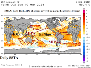
Fig. 1: Global SSTA analysis identifying marine heatwave location and the ongoing El Nino/+IOD pattern.
Review of global SSTA discussion: According to NOAA, marine heatwaves (MHW) covered 41% of the global oceans in January. The February value is not yet available, however, given the already reported record global ocean surface temperature (21.06C) MHW’s were likely a major contributor. Climate Impact Company identifies 8 MHW’s (outside of the tropics) in the current daily global SSTA analysis (Fig. 1). Most prominent are the MHW’s are in the subtropics of the North and South Atlantic Ocean leading to persistent record warm tropical North Atlantic (+TNA) and tropical South Atlantic (+TSA) index. The persistent +TNA index has already produced a record warm tropical cyclone (TC) heat potential (TCHP) in the North Atlantic basin (Fig. 2), months ahead of the onset of the TC season. A strong MHW south of Africa lead to anomalous high pressure and dryness for much of South Africa in February. The long-standing MHW in the Northeast Pacific has shifted west of the Dateline. Monitoring of a potential new MHW on the U.S. West Coast is underway. Ongoing MHW’s southwest and east of Australia have produced anomalous high pressure during just-ended meteorological summer. In between the subtropical high-pressure areas either side of Australia, an occasional weak trough has formed leading to unexpected heavy rain, at times, across eastern Australia (where El Nino usually causes summer drought).
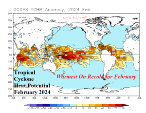
Fig. 2: The highest tropical cyclone heat potential in the Caribbean Sea/North Atlantic tropics on record for the month of February.
ENSO discussion: The 2023-24 El Nino was unique given the moderate-to-strong oceanic signature but lagging atmospheric character as defined by multivariate ENSO index (MEI). Interestingly, NOAA stopped issuing MEI values as of this month. Using a different approach to analog ENSO phase for 2024, Climate Impact Company takes a look at the peak ocean heat east of the Dateline late in the year of the ongoing El Nino compared to the loss of upper ocean heat as El Nino weakens the following February. This approach tries to address the lack of full-throttle El Nino intensity of the 2023-24 event as supported by MEI. The results are interesting. The upper ocean heat peak during late year of the El Nino compared to the heat loss by the following February most closely matches the 2023-24 sequence during 1982-83, 1994-95, and 2006-07 (Fig. 3). Note that most other El Nino events (since 1979) lose upper ocean heat more slowly. The Nino34 SSTA for each El Nino year helps to identify the type of El Nino observed in 2023-24 (Fig. 4). The Nino34 indicates while El Nino 2023-24 has some strong (El Nino) qualities, similar with 1982-83, the current event is more strongly biased toward weaker El Nino events of 1994-95 and 2006-07. Note that the analog becomes completely agreeable on La Nina formation by August with strengthening to follow for late 2024.
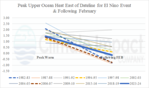
Fig. 3: Upper ocean heat maximum for late in the year of each El Nino episode since 1979 and the following February when upper ocean heat was easing as El Nino weakened.
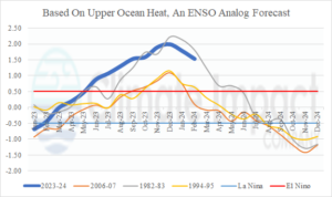
Fig. 4: Using analog years, the Nino34 SSTA to project likely ENSO phase for 2024.
