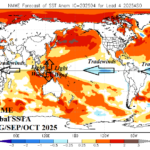
Is -IOD Potential for Q3/2025 Dependent on ENSO Flipping Back Toward La Nina?
04/29/2025, 4:39 pm EDT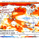
If Negative Indian Ocean Dipole Develops Q3/2025, La Nina Follows
05/05/2025, 12:43 pm EDT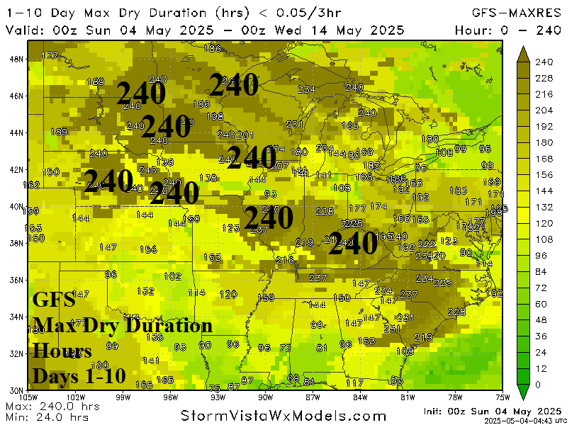
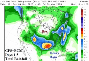
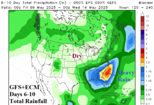
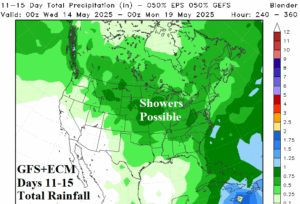

Fig. 1-4: The GFS+ECM days 1-15 U.S. rainfall forecast and maximum dry duration according to GFS through the next 10 days.
Discussion: The heavy rains of April shift into the Southern U.S. to start May heaviest over Louisiana early-to-middle week (Fig. 1). North of the rain, dry conditions persist. In the 6-10-day period, the wet pattern continues to shift eastward to the Southeast U.S. Coast (Fig. 2). The Midwest stays dry. In the 11-15-day forecast, heavy rain is absent, and GFS and ECM combine to produce marginal rain across the U.S. Corn Belt (Fig. 3). The GFS (and ECM) indicate 240-hour dry duration periods in the 10-day outlook for parts of Minnesota to Nebraska and Iowa to Kentucky (Fig. 4). While mid-spring brought extreme rain to the East-central and South-central U.S., areas to the north were dry and stay dry well into May!
Changes in the SSTA pattern across the Mediterranean and Black Sea are foreshadowing a pattern change for the Black Sea region. A long duration marine heatwave (MHW) continues to percolate in the Central Mediterranean Sea with warmer changes observed during April (Fig. 5-6). However, the East Mediterranean Se and Black Sea have turned much cooler! Implied is an upper air pattern where the upper ridge favors central or western Europe while the Black Sea region favors an upper trough. During the past 10 days, the pattern described has emerged as the upper ridge shifts toward U.K. and upper trough(s) become prominent over Northwest Russia and the east-central Mediterranean Sea (Fig. 7). The trend toward increased influence of a longwave trough is evident in the 15-day upper air forecast (Fig. 8) which causes an elongated area of persistent rains across Southern Europe and across the Black Sea region (Fig. 9). The France to Poland dry soils region misses the rain while the Black Sea region gains beneficial rainfall (Fig. 10).
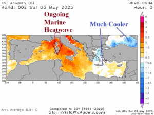
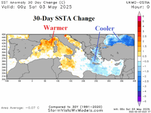
Fig. 5-6: The daily SSTA analysis of the Mediterranean and Black Sea plus the 30-day change.
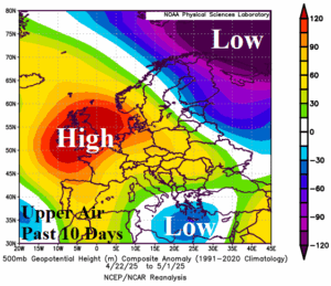
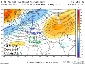
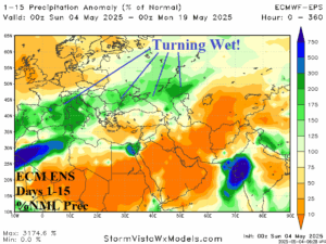
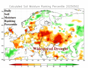
Fig. 7-10: The past 10 days upper air pattern across Europe, GFS ENS 15-day forecast and attendant rainfall, and where the Europe/Western Russia drought is located.