All Early July Seasonal Hurricane Forecasts are Updated with Increased Activity
07/10/2024, 8:35 am EDTHot Weather Causes Expanding Drought Risk in the U.S.
07/14/2024, 3:38 pm EDTExecutive Summary: The subsurface equatorial Pacific Ocean cooled significantly during MAR/APR 2024 providing a promising catalyst for La Nina development during the second half of 2024. However, the cooling is reduced by 50% during the past 2 months and combined with a persistent neutral southern oscillation index suggests the current neutral ENSO phase is likely to persist with weak La Nina still possible but at reduced risk.
Diagnostics: The tropical atmosphere is steady in neutral ENSO. The southern oscillation index (SOI) has displayed strong positive and negative daily extremes in July suggesting the Madden Julian oscillation (MJO) is active. However, the projected SOI for July is zero (Fig. 1). Except for February, monthly SOI has been neutral.
Normally, the trend of upper ocean heat in the equatorial Pacific east of the Dateline foreshadows an ENSO phase change. During MAR/APR 2024, the equatorial Pacific subsurface east of the Dateline shifted sharply cooler than normal justifying a likely ENSO phase change to La Nina in 1-3 months. However, and unusual is the subsurface equatorial Pacific east of the Dateline has lost about 50% of the cool signature 2-3 months ago (Fig. 2). Consequently, and ENSO phase change to La Nina is delayed and if the current “less cool” trend continues, ENSO may stay in neutral phase.
The 30-day global SSTA analysis reveals the lingering warmth east of the Dateline in the equatorial Pacific and marginal cool SSTA off the northwest coast of South America which averages neutral ENSO for mid-year (Fig. 3). Noten the dominance of marine heatwaves in the middle latitudes of both hemispheres possibly causing ENSO to stay neutral. Additionally, the previously robust warm equatorial region in the Atlantic Ocean has cooled significantly in recent weeks. Finally, in the tropical Indian Ocean, cooling in the western region while the eastern section warms signals possible negative phase Indian Ocean dipole (IOD) ahead.
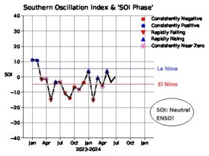
Fig. 1: Monthly plot of southern oscillation index for 2023 and 2024 so far.
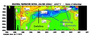
Fig. 2: The July 2024 equatorial Pacific upper ocean heat anomalies so far.
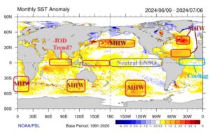
Fig. 3: The global SSTA analysis for the past 30 days as of July 6, 2024.
Forecast charts: Based on the average Nino34 SSTA between the NOAA/NCEP CFS V2, ECMWF, and Australia Bureau of Meteorology (Fig. 4), plus the Climate Impact Company constructed analog (Fig. 5), the ENSO phase probability forecast favors developing weak La Nina in the coming months lasting into early 2025 (Fig. 6). The Climate Impact Company 2-year ENSO phase forecast features a wide range of analog solutions which average weak La Nina ahead for the remainder of 2024, neutral ENSO for most of 2025, and weak La Nina returning late next year into early 2026 (Fig. 7). Given the wide range of possibilities the projection is made with low confidence although the likelihood of a major ENSO event over the next 2 years is low.
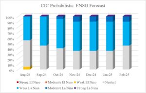
Fig. 4: The Climate Impact Company probabilistic ENSO phase forecast based on combining lead dynamic models and the CIC-CA forecast.
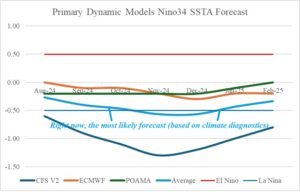
Fig. 5: The lead dynamic model ENSO phase forecasts of the Nino34 SSTA index of which the average solution is most reliable.
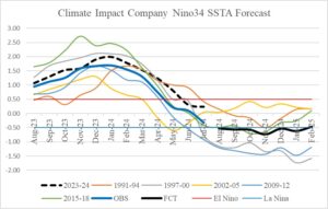
Fig. 6: The Climate Impact Company constructed analog forecast of the Nino34 SSTA through December 2025.
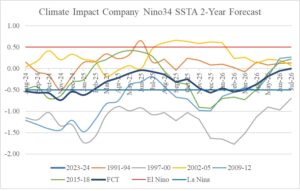
Fig. 7: The Climate Impact Company constructed analog forecast of the Nino34 SSTA through the next 2 years.