Heavy Rains Southern Brazil While Northern Brazil Becomes Hot/Dry
10/16/2024, 9:40 am EDTEarly November Tropical Cyclone Trouble Brewing
10/22/2024, 9:08 am EDTChart of the day: The PNA pattern forecast.
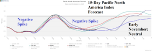
Discussion: On and off Great Plains wet weather for late October/early November is reliant on evolution of a negative phase Pacific North America (-PNA) index pattern. If -PNA develops, an upper trough cools the West and forces southerly flow out of the western Gulf of Mexico to interact with cold fronts in the Great Plains and cause rainfall. The 15-day forecast indicates a -PNA spike this week and again mid-to-late next week returning to neutral in early November. The week-2 rainfall forecast by ECM “weeklies” into early November is likely too wet as the PNA pattern is forecast flat at that time.
Week-2 Ahead Forecast valid October 27-November 2, 2024: Still warm Central and East; Patchy rains Central.
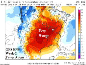
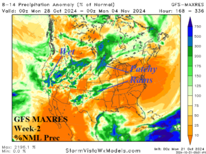
Discussion: -PNA pattern weakens during the period. Wet and cool weather in the West should begin to abate. Some of the wet weather can reach the Great Plains with patchy character. The very warm pattern east of the Continental Divide continues.
Week-3 Ahead Forecast valid November 3-9, 2024: Still warm. Signs of some wet weather in the East.
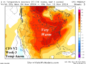
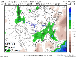
Discussion: Warm persistence is too strong to remove despite entering the 2024-25 cold season. However, there is increasing risk of wet weather in the East U.S.
Week-4 Ahead Forecast valid November 10-16, 2024: Still warm.
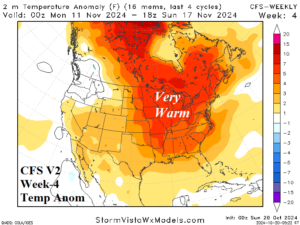
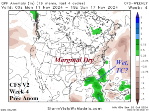
Discussion: CFS V2 mid-November forecast maintains warm weather and indicates a late season tropical risk for Florida.