Wet Pattern in Brazil Continues; Shifts South
11/27/2024, 10:34 am EST
Cold Stratosphere Just-after Mid-month in Polar Region
12/02/2024, 4:25 pm ESTDiscussion: An early meteorological winter 2024-25 cold wave is underway! The hardest hit energy sectors through the first third of December are NEPOOL, PJM-East, PJM-West, and SERC. In New England there are 2 cold spikes to the 10-day cold wave today and a colder peak late this week (Fig. 1). Boston is in the 30’s today with 20’s wind chill struggling to reach 32 late in the week with wind chill in the teens.
The PJM-East sector cold wave should ease in 9 days (Fig. 2). Cold peaks start and finish this week. Philadelphia is in the 36-40 range to start the week and closes the week in the 34-38 range. Temperatures at night are in the low to middle 20’s.
The PJM-West cold lasts another 7-8 days with cold peaks today and Thursday (Fig. 3). Chicago reaches only 25 today and Thursday.
Finally, the chill extends to SERC. Cold peaks are midweek and early next weekend (Fig. 4). Atlantic reaches the low 40’s Tuesday and middle 40’s FRI/SAT. At night, lows drop to the middle 20’s.
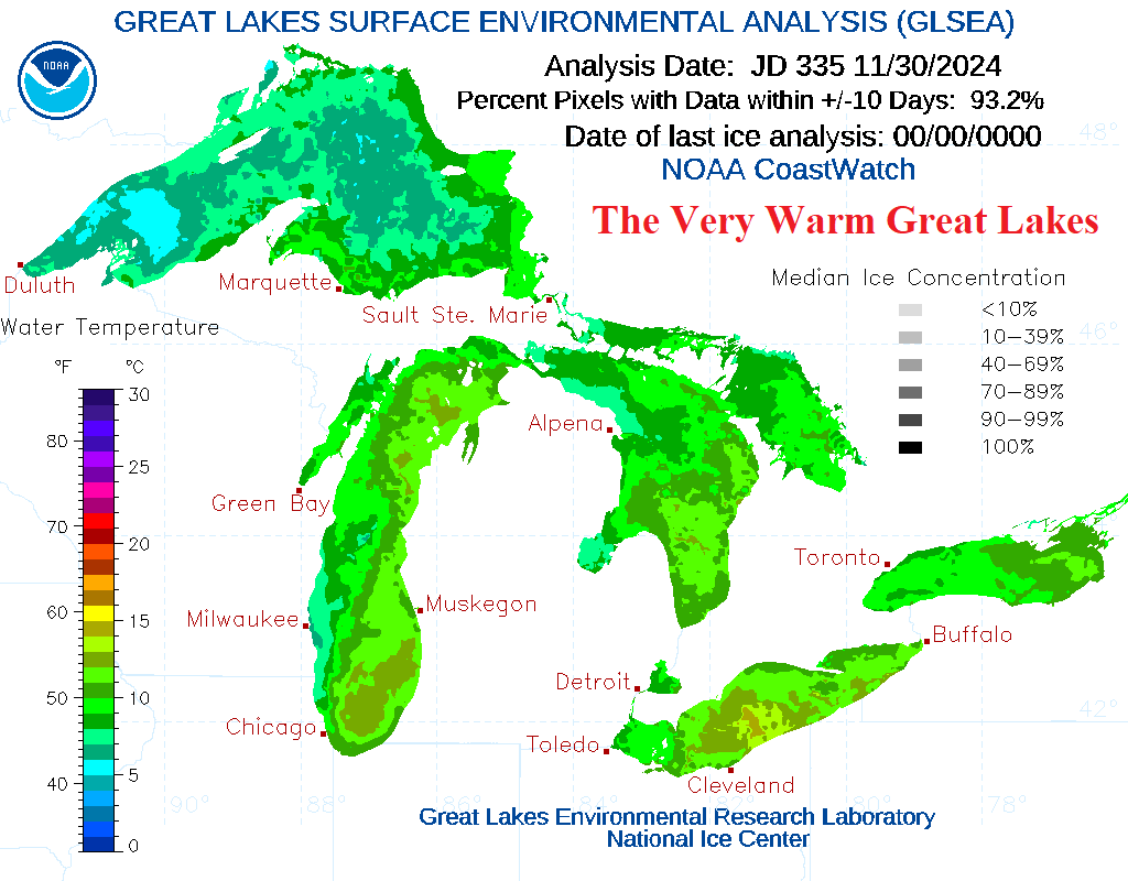
The Great Lakes are exceptionally warm, averaging in the upper 40’s to low 50’s (Fig. 5) and with a steady arctic air mass crossing over the lakes an immense lake-effect snowfall event is underway. The 1-5-day GFS snowfall forecast indicates an extreme amount from Western Michigan to New York (Fig. 6) with widening southern extent due to Alberta Clipper storms in the 6-10-day period (Fig. 7). Increasing snow cover will enhance the cold, particularly daytime as clod cover blocks sunlight.
The U.S. gas population weight HDD forecast identifies the very cold start to December (Fig. 8). However, the forecast is much warmer next week as the cold pattern breaks (except New England). The extended range forecast into mid-month warms the HDD projection to near the 10-year normal. The week 4-6 forecast indicated by the CFS V2 and ECM is interesting. Both models are moderately cold for the week ending Dec. 26 (Fig. 9). However, ECM maintains moderate cold into early January while CFS V2 is wildly cold for the week ending Jan. 9. The cold HDD forecast for Jan. 3-9 by CFS V2 indicates presence of a “polar vortex” regime.

Fig. 1: The NEPOOL System daily temperature departure from normal.

Fig. 2: The PJM-East System daily temperature departure from normal.

Fig. 3: The PJM-West System daily temperature departure from normal.

Fig. 4: The SERC System daily temperature departure from normal.

Fig. 5: The daily Great Lakes sea surface temperature analysis.


Fig. 6-7: GFS snowfall forecasts for days 1-5 and days 6-10 across the East U.S.

Fig. 8: The U.S. gas population weight HDD forecast utilizing all models, their consensus, comparison with 48 hours ago and the 30-year/10-year normal.

Fig. 9: The latest extended-range U.S. gas population weight HDD forecast comparing CFS V2 and ECM and their consensus.

