The Likelihood of Abundant Northern Hemisphere Early Season Snow Cover
09/21/2024, 9:03 am EDT
East U.S. Cold Days 11-15: GFS/ECM Vs. AI Forecasts
11/26/2024, 8:40 am ESTExecutive Summary: The updated month 1-4 climate outlook for the U.S. features increasing forecast confidence based on the influence on North America climate by dramatic cool phase of the Pacific decadal oscillation and warm phase of the Atlantic multi-decadal oscillation. A weak ENSO regime has limited influence. The forecast emphasizes anomalous warmth across the eastern half of the U.S. with cold risk, mostly in December and February, affecting the western states. An expanding drought across the Southern U.S. is likely.
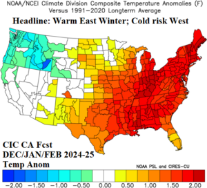
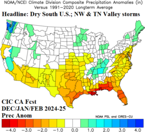
Fig. 1-2: The Climate Impact Company constructed analog temperature and precipitation anomaly forecast for meteorological winter DEC/JAN/FEB 2024-25.
Climate discussion: Becoming apparent during November, and likely to continue through winter 2024-25, is the effect on North America climate of the strongest negative Pacific decadal oscillation (-PDO) on record. The -PDO is present due to the difference in SSTA of historical warmth across the Northwest Pacific and comparatively weak warm SSTA in the Northeast Pacific. The effect on the upper air pattern favors the presence of a wintertime upper trough at various locations on the West Coast of North America fueling cold and storm risk. In the North Atlantic basin, a persistent historically warm Atlantic multi-decadal oscillation (+AMO) continues. The effect on eastern North America climate is above normal 500 MB heights fueling a persistent warmer than normal climate. The -PDO/+AMO regimes will dominate the North America climate for winter 2024-25. Polar vortex episodes are possible strongly favoring Western Canada if they occur. ENSO is in neutral phase and while weak La Nina is possible, the effect of ENSO on the winter climate pattern is limited.
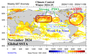
Fig. 3: The current global SSTA regime identifies prevailing SSTA regions affecting North America climate, not likely to change much during winter 2024-25.
December 2024 outlook: Building cold in Southwest/West Canada extending to the Northwest U.S. is a forecast change for early meteorological winter. The storm track shifts south, battering California, and enables cold air to filter southward from the Western Canada source region into the Northwest U.S. The cold extends across the North-central U.S. at times where snow cover increases. At times, some of these cold air masses extend eastward although moderating south of snow cover. The Ohio Valley to Mid-Atlantic stretch is adjusted colder to near normal. The drought affecting the Northeast U.S. is likely to continue. The Southern U.S. is warmer and drier than normal.
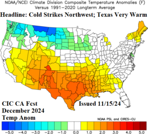

Fig. 4-5: The Climate Impact Company December 2024 temperature and precipitation anomaly outlook.
January 2025 outlook: The mid-winter outlook is very warm and represents the full throttle influence of a mid-winter -PDO/+AMO climate pattern. The strongest warmth is down-slope the Continental Divide and the mild Pacific flow extends to the East Coast. The pattern is a classic snow eater regime as mid-winter is biased very warm (also) due to lack of snow on the ground. The storm tracks are evident in the Northwest with mostly rain events from the Tennessee Valley to New England.
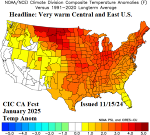
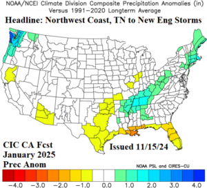
Fig. 6-7: The preliminary Climate Impact Company January 2025 temperature and precipitation anomaly outlook.
February 2025 outlook: Significant cold is forecast for late meteorological winter. Featured, is arctic air and widening snow cover across the Interior West to hold the cold. Most of the West U.S. precipitation is snowfall along and just west of the Continental Divide while the immediate West Coast is very dry. The storm track is prominent in the East U.S. stretching from the Mid-south States to the Ohio Valley and Quebec. The back side of the storm track features significant snow. Proximity of snow to Texas supports brief periods of cold reaching that southern latitude. However, the cold moderates shifting eastward as lack of snow cover in the East maintains a warm climate.
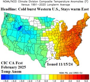

Fig. 8-9: The Climate Impact Company February 2025 temperature and precipitation anomaly outlook.
March 2025 outlook: Late calendar winter features a repeat of the February pattern as the cold holds across the West and East U.S. warmth prevails. Texas will turn warmer. The storm track regenerates in California and is vividly present across the Midwest U.S. The East Coast turns much drier in March.
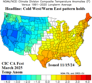

Fig. 10-11: The preliminary Climate Impact Company March 2025 temperature and precipitation anomaly outlook.
