Most Severe Weather Reports of 2024 Was May 26
05/27/2024, 2:19 pm EDTThe Northeast Pacific Marine Heat Wave is Strengthening!
05/30/2024, 8:41 am EDT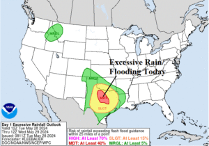
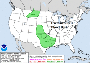
Fig. 1-2: NOAA/WPC excessive rainfall and flooding risk for today and tomorrow.
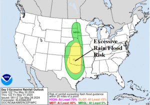
Fig. 3-4: NOAA/WPC excessive rainfall and flooding risk for Thursday and Friday.
Discussion: Severe thunderstorms bring heavy rain in Texas today where widespread flooding is likely later today and tonight. The maximum risk is across central and north-central Texas (Fig. 1). Redeveloping heavy rain and flood risk occurs in Texas and the southwest/south Great Plains on Wednesday (Fig. 2). The THU/FRI flood risk is impressive and likely to increase from Kansas to Texas and eastward to Arkansas (Fig. 3-4). Several areas of flood risk are forecast for Saturday (Fig. 5). The NOAA/WPC quantitative precipitation forecast (QPF) is 4-8 in. across Northern Texas (Fig. 6). Damage from widespread high wind gusts is expected today for most of Texas (Fig. 7). Another high wind event related to severe thunderstorms across northwest Texas on Thursday (Fig. 8). In the medium range, excessive heat is an increasing issue. Risk of >100F extends across the Southwest U.S. and into California (Fig. 9-10). The U.S. population weight cooling degree day (CDD) forecast indicates above normal cooling demand through June 13 (Fig. 11) including a warmer trend forecast for next week.
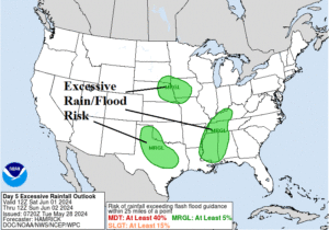
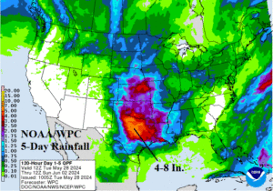
Fig. 5-6: NOAA/WPC excessive rainfall and flooding risk for Saturday and 5-day rainfall amount forecast.
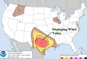
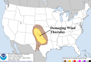
Fig. 7-8: NOAA/SPC maximum damage risk areas caused by severe storms today and Thursday.
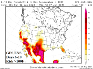
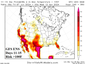
Fig. 9-10: GFS ENS >100F risk forecast for the medium range.
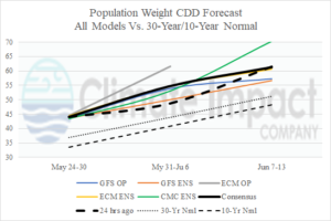
Fig. 11: The U.S. population weight CDD forecast utilizing all models, their consensus, and comparing with 24 hours ago and the 10-year/30-year normal.