Surprises! Possible TC East of New Jersey Monday? Cooler Looking U.S. 11-15-day Outlook?
07/26/2024, 6:33 am EDTMid-South U.S. Flash Drought Followed by Some Relief After 10 Days
07/31/2024, 11:13 am EDT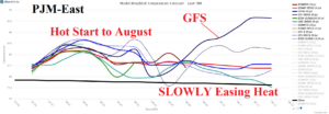
Fig. 1: PJM-East 15-day system temperature forecast by all models.
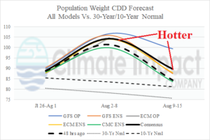
Fig. 2: U.S. population weight CDD forecast through mid-August.
Discussion: Potentially, an important forecast change for August 9-15 is indicated by GFS for the electricity high demand zone PJM-East. The GFS pushes the developing upper trough in Canada next week westward in the 11-15-day period which forced a compensating hot pattern in the East U.S. The PJM-East system average temperature is well above normal next week and most models ease (slowly) the anomalous heat into mid-August (Fig. 1). However, GFS spikes PJM-East hot again and hotter than next week. The hotter GFS influence shifts the national CDD forecast somewhat warmer from 2 days ago (Fig. 2).
In the short-term, Heat Advisories and Excessive Heat Warnings are expanding in the South-central/Mid-south U.S. to the Gulf States (Fig. 3). High temperatures reach (or exceed) 105F in the warning areas with heat index in the 110’s. Climate Impact Company maintains a flash drought risk to the east/southeast Great Plains added to a similar risk indicated by NOAA for the west and northwest Great Plains.

Fig. 3: NOAA/NWS weather watch, warning, and advisories.
“Ring of fire” thunderstorms pounce on the Midwest to Appalachian States this week (Fig. 4). Damaging wind gusts caused by severe thunderstorms are likely in the U.S. Corn Belt today (Fig. 5) and Western Corn Belt tomorrow (Fig. 6) to the Ohio Valley on Thursday (Fig. 7).
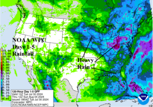
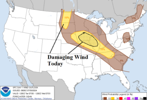
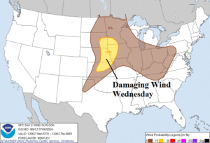
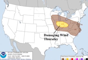
Fig. 4-7: NOAA/WPC 5-day quantitative precipitation forecast and NOAA/SPC areas with potential damaging wind from severe thunderstorms the next 3 days.