
February 2025 and DEC/JAN/FEB 2024-25 U.S. State Temperature and Precipitation Rankings
03/11/2025, 9:07 am EDT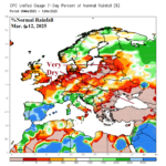
Dry Pattern Central Europe to Black Sea Region Continues as Drought Worsens
03/14/2025, 3:45 pm EDT


Fig. 1-4: NOAA/SPC severe weather and tornado risk areas for FRI/SAT.
Discussion: The largest severe weather outbreak of the early season is forecast for tomorrow in the East-central U.S. and Southeast States on Saturday. Tomorrow’s outbreak risk area stretches from the Upper Midwest to the Gulf Coast and features a large area of tornado risk from Illinois to Mississippi (Fig. 1-2). Synoptic scale high wind accompanies the large mass of thunderstorm activity. On Saturday, the severe weather area redevelops in the Southeast U.S. with tornadoes likely is Mississippi and Alabama (Fig. 3-4). Tennessee Valley has the highest risk of extreme rain and flooding on Saturday. Severe storms stretch along the Atlantic Seaboard on Sunday.
High synoptic scale wind events are ahead beginning tomorrow in Texas where gusts reach hurricane force during the afternoon (Fig. 5). The high wind gust potential shifts to Illinois Friday night when gusts to 65 mph are possible (Fig. 6). The high wind gust zone shifts to the eastern Ohio and Tennessee Valley Saturday night (Fig. 7) and across the Mid-Atlantic and Northeast States Sunday afternoon (Fig. 8).


Fig. 5-6: High wind gust areas Texas to Illinois tomorrow.


Fig. 7-8: High wind gust areas Eastern Ohio/Tennessee Valleys to the East Coast on the weekend.