Helene Likely to Reach Category-4 Major Hurricane Intensity Making Landfall in Northwest Florida
09/26/2024, 5:42 pm EDTExtended hot weather for California.
09/29/2024, 3:35 pm EDT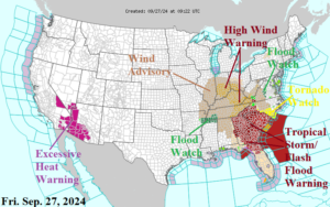
Fig. 1: Current NOAA/NWS weather watch, warning, and advisory areas.
Discussion: Helene made landfall at 11:10PM EDT last evening as a category-4 major hurricane near the mouth of the Aucilla River in the northwest Florida Big Bend area. At 5AM EDT, Helene is downgraded to a tropical storm located at 32.8N/83.0W or about 40 miles east of Macon, GA. Helene is racing northward at 30 mph with top wind near 70 mph and surface pressure 968 MB. Widespread destructive effects associated with this storm continue. Tropical Storm and Flash Flood warnings cover Northern Florida, Georgia, and South Carolina. A Tornado Watch is issued for the eastern Carolinas. High wind is a major issue extending northward today across the Tennessee and Ohio Valley(s). A High Wind Warning is issued along Helene’s projected track across East Tennessee, East Kentucky, Southwest Ohio, and the southern 2/3 of Indiana. In the Southwest U.S., another major heatwave as Excessive Heat Warnings are issued.
Today’s tornado risk area is widespread and includes the Carolinas to Southern Virginia (Fig. 2). Today’s excessive rainfall covers the entire Tennessee Valley and extends to the southern Ohio Valley with extreme risk in western Tennessee and throughout the southern Appalachians (Fig. 3). Flooding rainfall lingers tomorrow centered on Kentucky (Fig. 4).
Wind gusts across the Tennessee Valley into the Ohio Valley today will reach the 50-55 mph range causing power outages. The GFS 4-5PM EDT projection implicates southern Indiana for damaging wind (Fig. 5).
Climate Impact Company initiates the U.S. gas population weight HDD forecast (Fig. 6).
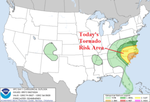
Fig. 2-4: Today’s tornado risk area is across the Carolinas while the excessive rainfall/flash flood risk zone extends across the Tennessee Valley and vicinity to the Interior Mid-Atlantic. Flooding rainfall is likely in Kentucky tomorrow.
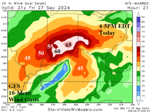
Fig. 5: GFS 10-meter wind gust forecast valid 4-5PM EDT today. About 80% of the wind indicated reaches the ground.
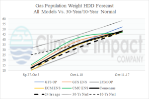
Fig. 6: Initiating the U.S. gas population weight HDD forecast using all operational models, and their consensus compared with 24 hours ago and the 30-year/10-year normal.