Finally, Some East Europe/Southwest Russia Snow Cover and Following Cold
02/18/2025, 8:19 am EST
Turning Very Hot in Australia, Tropical Cyclone Risk Queensland Next Week
02/25/2025, 12:35 pm EST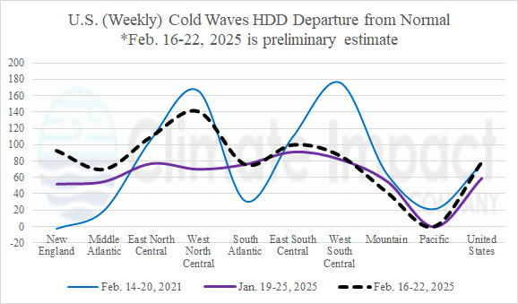
Fig. 1: The departure from 30-year normal U.S. gas population weight HDD for 9 NOAA regions across the U.S. for cold events “Uri” in FEB-21, “Enzo” in JAN-25, and the current (unnamed) cold outbreak. Projections for the current event are preliminary and not tabulated until early next week.
Discussion: The polar vortex event for the week of February 16-22, 2025, is preliminarily projected to generate 270 HDD for the U.S. which is comparable to the arctic outbreak and Winter Storm “Enzo” during January 19-25, 2025, and the arctic outbreak and Winter Storm “Uri” during February 14-20, 2021. The departure from normal HDD chart (Fig. 1) for each event reveals “Uri” was coldest, compared to normal, in the West-North Central U.S. (SPP region) and the West-South Central U.S. (ERCOT). The event of this week, compared to normal, is preliminarily projected to be colder than the event last month especially in the SPP region.
Although the stratosphere is, on average, colder than normal this winter season, two brief stratospheric warming events on the North America side of the North Pole triggered the polar vortex pattern last month and this week. This week’s weather was made (more) harsh as the onset of stratospheric warming across Canada early last weekend was coupled with an eastward surge of tropical convection in the longitude of the Americas associated with the Madden Julian oscillation (MJO). The polar and tropical forcing caused the exceptionally intense storm on Sunday triggering many hundreds of severe weather reports across the Southeast U.S. (including tornadoes), historic flooding in Kentucky, and widespread high wind from the Mid-Atlantic to Northeast U.S.
The ongoing cold event is most intense across the Great Plains and into Texas expanding into the Southeast U.S. this morning (Fig. 2). The cold is made more effective by fresh snow cover stretching across Kansas and eastward. Lingering snow is affecting the Mid-Atlantic States this morning. Morning low temperatures range from 15F in Dallas to 3F in Oklahoma City to -10F in Omaha and -23F in Bismarck.
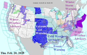
Fig. 2: Current NOAA/NWS weather watch, warning, and advisory areas.
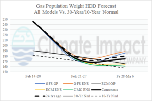
Fig. 3: U.S. gas population weight HDD forecast utilizing all models, their consensus, and comparing with the forecast from 48 hours ago plus the 30-year/10-year normal. The outlook is warmer for next week and marginally cold for early March.
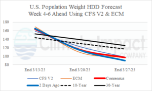
Fig. 4: Utilizing CFS V2 and ECM, the U.S. gas population weight HDD forecast for mid-to-late March indicates a chilly week of March 7-13 followed by a warmer than normal mid-to-late March.