Hot and Dry Combination Accelerates Drought Risk West and East U.S.
06/28/2024, 9:10 am EDTBeryl: Texas Preparations Warranted!
07/02/2024, 12:15 pm EDTDiscussion: The 4-5-day forecast track toward the Yucatan Peninsula is reasonably confident. However, once Beryl moves across the Yucatan, “track clusters” have mixed opinions on Beryl (Fig. 1). The most confident forecast is a potential north turn (41.7%) while the second-most likely track is a continued due west course (37.9%). The least likely track is across the northern Yucatan Peninsula and eventually toward Texas (20.4%). So…the western Gulf needs to monitor closely for a possible major issue next weekend. Tropical cyclone 5-day forecast tracks indicate a large spread in possibilities once Beryl reaches the west/northwest Caribbean Sea (Fig. 2). The intensity forecasts indicate some weakening of Beryl once into the western half of the Caribbean Sea due to the presence of westerly shear (Fig. 3). Models indicate weakening to a tropical storm with Beryl moving across the Yucatan Peninsula later this week. Of concern is the Navy model which maintains a major hurricane implying a potential direct entry to the southeast Gulf.
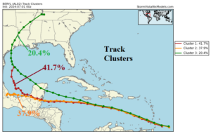
Fig. 1: Track clusters forecast tracks for Beryl.
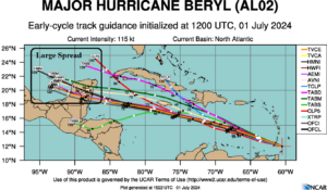
Fig. 2: Tropical cyclone tracks for Beryl.
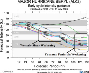
Fig. 3: Tropical cyclone intensity forecast for Beryl.