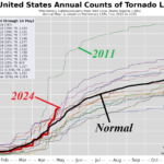
The 2024 Severe Weather Season So Far; Second-most Tornadoes
05/15/2024, 9:20 am EDT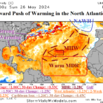
Tropical Feature: The westward push of a warming ocean surface in the North Atlantic.
05/28/2024, 3:54 am EDT
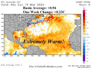
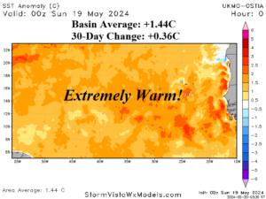


Fig 1-4: The prohibitive warmer than normal North Atlantic basin is trending warmer during late spring.
Discussion: The daily North Atlantic basin sea surface temperature anomaly (SSTA) is +0.94C and implies the Atlantic multi-decadal oscillation (AMO) is similar and therefore easily a record warm value for May (Fig. 1). The North Atlantic basin has warmed 0.23C during the past 7 days. A primary contributor is the tropical North Atlantic (TNA) index located across the main development region (MDR) for hurricanes (Fig. 2). The daily TNA index is +1.46C maintaining the record warm signature in this part of the outer tropical North Atlantic basin. The TNA index has warmed by 0.36C during the past 30 days. In the Caribbean Sea, the daily SSTA basin average is +1.21C which is a 30-day warm-up of 0.36C (Fig. 3). Finally, the Gulf of Mexico is warming fast reaching +1.21C which is a change of 0.5C over the past 30 days (Fig. 4).