Fine Line for Wet Vs. Dry in Central U.S. Summer 2024?
05/14/2024, 6:03 am EDT-IOD/ENSO Regimes across South America for OCT/NOV and DEC/JAN
08/09/2024, 4:15 pm EDTDiscussion: As of mid-May, the U.S. severe weather season has produced the second-most number of tornadoes so far, and second only to 2011 (Fig. 1). Tornadoes have been equally distributed across the Central U.S., Ohio Valley, and Southeast U.S. (Fig. 2). The 2024 severe weather season has produced an unusual amount of severe hail focused on “tornado alley” from Central Texas to the Central Plains and Missouri Valley (Fig. 3). Severe wind reports have been widespread across the eastern half of the U.S. except the far northern states and New England (Fig. 4). Severe wind reports have affected Coastal California and parts of the Interior West. The upper air pattern during MAR/APR/MAY 2024 (so far) has featured a persistent upper trough over the Southwest U.S. forcing the subtropical jet (STJ) stream to arc northeastward across Mexico to the Southeast U.S. inspiring low-level jet (LLJ) streams forcing buoyant moisture northward from the warmer than normal Gulf of Mexico (Fig. 5). The intersection of the upper-level high wind band over a lower atmosphere channel of warm moist air is causal to severe weather. Interestingly, the 2011 set-up was different (Fig. 6). The upper trough was over the Northwest U.S. and the distribution of severe weather was farther east (Mid-south U.S. to the Appalachian States). ENSO was not a significant contributor as La Nina was present in 2011 while this year observed fading El Nino.
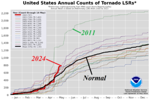
Fig. 1: The NOAA/SPC tornado count so far in 2024 is second highest to 2011.
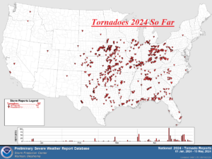
Fig. 2: The NOAA/SPC tornado damage report locations so far in 2024.
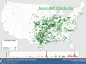
Fig. 3: The NOAA/SPC severe hail damage report locations so far in 2024.
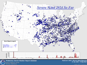
Fig. 4: The NOAA/SPC severe wind damage report locations so far in 2024.
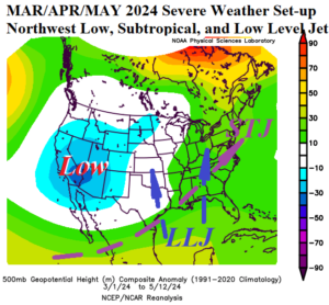
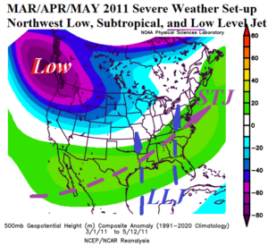
Fig. 5-6: The upper air pattern for MAR/APR/MAY 2024 vs. 2011, both big severe weather meteorological spring(s).