U.S. Warm and Dry Pattern Continues, Drought Expansion!
10/04/2024, 11:35 am EDTMilton Reaches Category-5 Major Hurricane Status at 11:05 EDT
10/07/2024, 12:17 pm EDT
Fig. 1: The NOAA/NHC timing of the onset of tropical storm conditions.
Discussion: We begin with the NOAA/NHC onset of tropical storm force wind for Florida (plus the north/northeast Gulf Coast). This timing projection is a good guide for storm preparations to be completed. Storm preparations for the coastal northeast Gulf where tropical storm conditions are expected are 8PM Monday (Fig. 1). The deadline for storm preparations on the West Coast of Florida where major hurricane conditions are expected is late Tuesday afternoon. Storm preparation on the East Coast of Florida where hurricane conditions are anticipated is Tuesday evening.
At 8AM EDT, Tropical Storm Milton was located at 22.6N/94.9W or about 860 miles west-southwest of Tampa, FL. Maximum sustained wind is 60 mph, and Milton is moving east at 5 mph. Central pressure has lowered to 991 MB. Milton is notably stronger this morning while turning due east with a slightly faster forward speed. The NOAA/NHC 5-day outlook (Fig. 2) strengthens Milton to a hurricane tonight with due east movement continuing to early Tuesday followed by intensification to a category-3 major hurricane while turning east-northeast Tuesday afternoon. Milton maintains that track and makes landfall as a category-3 major hurricane in the Tampa, FL area late Wednesday afternoon. Milton maintains hurricane intensity exiting the East Coast of Florida near Cape Canaveral early Thursday morning and is likely to become an extra-tropical storm northeast of the Bahamas entrained by the jet stream late this week.
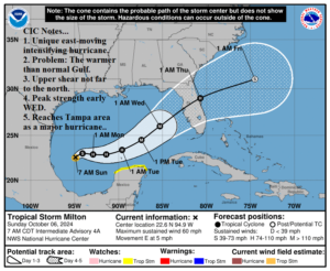
Fig. 2: The NOAA/NHC 5-day forecast track for Tropical Storm Milton.
Milton is a rare eastward moving intensifying tropical cyclone this week. The upper shear which could wreck Milton is not far to the north. The much warmer than normal Gulf of Mexico enables rapid intensification through Tuesday. Milton nears the shear axis approaching the West Coast of Florida therefore some weakening could occur. However, as seen with other hurricanes this year (Beryl and Helene) the initial encounter with increasing wind aloft from the synoptic weather pattern has caused the hurricane to strengthen. Therefore, a category-3 major hurricane is anticipated at landfall in the Tampa, FL area later Wednesday afternoon. The satellite view indicates Milton is organizing (Fig. 3) while peak intensity forecasts are early Wednesday by HMON with near category-4 intensity (Fig. 4). The hurricane models are slower and stronger than the NOAA/NHC forecast but weaken Milton while approaching the Florida Coast. NOAA/NHC has delayed the storm surge forecast due to these complexities in the eastern Gulf. However, a life-threatening (>10 foot) storm surge is a likely scenario for a large portion of the Florida West Coast.
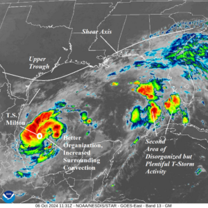
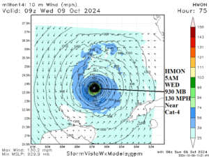
Fig. 3-4: Weather satellite view of Milton and the HMON peak intensity forecast.
Tropical cyclone models are reasonably confident on a forward track toward Tampa (Fig. 5) but vary widely on potential maximum intensity (Fig. 6). The preliminary rainfall forecast indicates a peak amount of near 25 inches off the West Coast of Florida where NOAA/NHC anticipates peak strength (Fig. 7). Note the most dangerous flooding area is near and north of Tampa (Fig. 8) as interaction with the jet stream shifts the heaviest rain north of the path of travel. South of the track, an immense tornado risk will affect much of central and southern Florida.
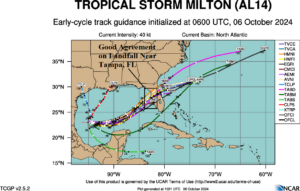
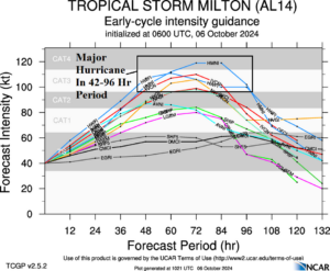
Fig. 5-6: Tropical cyclone models track and intensities for Milton.
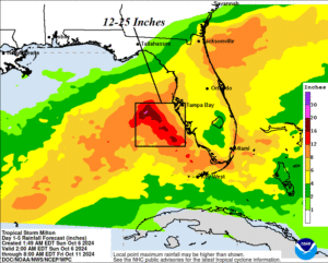
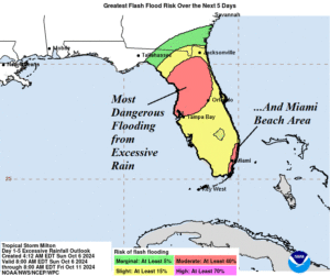
Fig. 7-8: The rainfall forecast associated with Milton plus the most likely dangerous flash flood areas.