Emerging Marine Heatwave Off East Coast of South America; Correlated to Increased Summertime Argentina/Western Brazil Drought Risk
11/06/2024, 2:48 pm ESTOctober 2024 Produces the Strongest Monthly -PDO in the 1950-2024 Climatology
11/08/2024, 3:50 pm ESTExecutive summary: La Nina development has stalled due to the passage of Madden Julian oscillation through the tropical East Pacific/Atlantic/Africa sector in early-to-middle November. The window of opportunity for La Nina development (usually during quarter 4) is eroding. Consequently, neutral ENSO may extend through the upcoming northern hemisphere winter. In 2025, the ENSO forecast WAS neutral ENSO and possibly a second attempt at La Nina later next year. That possibility remains but is considerably weaker. Added to the potential scenarios of ENSO phase during the second half of 2024 is an El Nino analog and shift by ECMWF favoring Nino34 SSTA shifting into an El Nino.
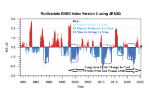
Discussion: During the middle 1990’s to present time long-term flip of the ENSO cycle to the cool phase, La Nina events are more frequent, some La Nina episodes are unusually strong, and El Nino events are shorter duration and weaker except for the 2015-16 event (Fig. 1). Currently, La Nina is forecast to develop by NOAA and last through the northern hemisphere winter 2024-25 season. The intensity forecast is weak.

Fig. 1: Using multivariate ENSO index the phases of ENSO are identified for 1980-2024.
Current ENSO diagnostics support neutral phase. The Nino34 SSTA index has not reached the -0.5C La Nina threshold and the southern oscillation index (SOI) is variable, most recently negative, and not able to meet the +0.5C La Nina threshold. Both the Nino34 and SOI threshold must be reached for at least 1-2 months for La Nina onset declaration. Subsurface cooling of the eastern equatorial Pacific Ocean is available but diminished since the APR-24 and SEP-24 peaks.
An ongoing strong convection phase of the Madden Julian oscillation (MJO) transiting the tropical Atlantic has reversed the tendency of ENSO to favor La Nina development during SEP-24. Since that time, trade winds have eased, and the up-welling process of cool water to the surface has slowed. Typically, La Nina develops during Q4 and based on current conditions and lingering negative effects from MJO a La Nina onset over the next 1-2 months is in doubt. Neutral ENSO is favored for winter 2024-25.
The interesting issue becomes what follows (CIC-neutral/NOAA-weak La Nina) for mid-to-late 2025? During the current cool phase of the long-term ENSO cycle, neutral ENSO to very weak La Nina events are confined to the 2001-2007 timeframe utilizing multi-variate ENSO index. During that time, ENSO phase averaged neutral with embedded brief weak La Nina/El Nino spikes. A second analog is the 2010-12 sharp La Nina, similar with the 2020-22 episode, followed by a brief attempt at La Nina (as forecast by NOAA the next 1-3 months) reversing to a strong El Nino in 2015.
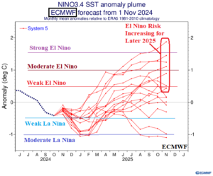
Suddenly, ECMWF is favoring the development of El Nino in the extended range forecast valid for the second half of 2025 (Fig. 2). Previously, neutral ENSO or a second attempt at La Nina generation was indicated by most forecast models. Two of the 16 Nino34 SSTA forecast ensembles maintain the La Nina risk while about half of the members are in the El Nino range. Consequently, the La Nina to El Nino transition of early-to-middle last decade is a potential analog for ENSO phase later next year into 2026.

Fig. 2: ECMWF ENSO outlook identifies El Nino risk for the second half of 2025.
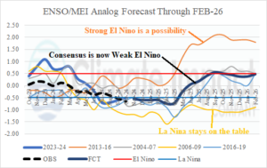
The Climate Impact Company analog forecast of ENSO phase using MEI indicates a WIDE range of possibilities (Fig. 3). The El Nino risk is introduced as a consensus of all the possibilities which adds a significant El Nino risk for the second half of next year.

Fig. 3: The Climate Impact Company ENSO analog forecast through FEB-26 using multivariate ENSO index.
Summary: ENSO phase remains neutral despite forecasts for La Nina onset. The climatological window for La Nina development is shrinking. The Nino34 SSTA oceanic La Nina is in doubt while a weak La Nina climate as identified by multivariate ENSO index is present but unlikely to strengthen and could weaken. During mid-to-late 2025, most statistical/dynamic models indicate neutral ENSO and a possible second attempt of La Nina generation. Some analogs suggest ENSO could shift toward El Nino. To substantiate the El Nino analog, ECMWF has shifted their Nino34 SSTA forecast for the second half of 2025 into the El Nino category. Consequently, El Nino risk is on the table for the second half of 2025 and the consensus of all forecasts shifts toward a borderline El Nino for the second half of 2025. The El Nino analog year is 2015. A marine heat wave (MHW) emerging in the Northeast Pacific was causal to the intensity of that El Nino episode. MHW’s are (very) active now and could help to inspire the return of EL Nino in 2025.
