An Unusual Upper Air Pattern for North America During Winter 2024-25
03/11/2025, 9:02 am EDT
Unusually Low Pressure Fueled the Weekend Severe Weather Outbreak
03/18/2025, 2:55 pm EDTExecutive summary: The influence of the Pacific decadal oscillation on Southwest Canada/Northwest U.S. climate has changed due to the warming of the North Pacific Ocean. Cool phase PDO events are now much warmer and have eliminated the previous cool/wet bias to the Southwest Canada/Northwest U.S. climate in favor of warmer and drier regimes.
Climate discussion: A key component of the climate system producing the precipitation pattern across Southwest Canada and the Northwest U.S. is the Pacific decadal oscillation (PDO). Currently, the PDO is in the negative (cool) phase present this entire decade (Fig. 1). However, the current -PDO is considerably different from ALL previous long-duration -PDO regimes due to the much warmer SSTA pattern across the North Pacific (Fig. 2). The “new” -PDO regime is caused by the relative cooler waters of the Northeast Pacific when compared to the extremely warm central and western North Pacific (north of 20N). -PDO regimes are well-correlated with the presence of cool ENSO (La Nina). However, in the new -PDO regime, classic La Nina existence is not guaranteed.
The “new” -PDO pattern has evolved this decade. Last year, the annual SSTA pattern across the North Pacific produced a strong -PDO regime. However, unlike all previous -PDO regimes, the Northeast Pacific was warmer than normal but considerably less (anomalous) warm than the record warmth of the northwest and central North Pacific (Fig. 3). Note the parallel warming of the North Atlantic basin and the independence the mid-latitude warming seems to have compared to ENSO.
The last long duration -PDO regime was observed during 2007-2013. Revealed in the SSTA analysis is the (previously) well understood -PDO classic relationship of cool SSTA in the Northeast Pacific compared to moderately anomalous warm SSTA of the Northwest and Central North Pacific (Fig. 4). The differences in the upper air pattern across Southwest Canada and Northwest U.S. in the new versus old -PDO regime is dramatic.
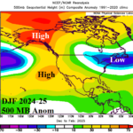
During the new -PDO regime of this decade, the prevailing upper air pattern has featured a large high-pressure ridge across the (mostly) anomalous warm SSTA of the North Pacific (Fig. 5). The conventional upper air pattern during long duration (old) -PDO (observed during 2007-2013) featured a semi-permanent upper trough extending from Alaska to the Northwest U.S. (Fig. 6). The new PDO regime is warmer and drier across Southwest Canada and the Northwest U.S. as the warmer waters defeat the historical upper trough attached to northwest North America.
The warming waters of the North Pacific are caused by the increasing presence and intensity of marine heatwaves (MHW). A dramatic increase in global MHW’s during the past decade is evident by the tendency for global SSTA routinely observed at or near record warmth. Monitoring and forecast MHW’s as part of the climate system is now routine. Until recently, the MHW off the East Coast of Asia extending past the Dateline was the strongest MHW on record which intensified the -PDO pattern as the Northeast Pacific was less (anomalous warm). Despite the continued strong -PDO, MHW NEP24A continues west-southwest of California (Fig. 7). NEP24A was a significant contributor to late 2024 upper-level high-pressure ridging drying out California causal to the Los Angeles Basin late season fire episodes. MHW’s are strongly linked to upper-level high pressure ridging.
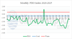
Fig. 1: The monthly PDO index for the current decade indicates a lengthy steady negative (cool) phase.
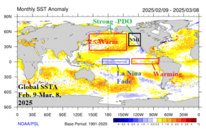
Fig. 2: The global SSTA from the past 30 days reveals presence of the “new” cool phase Pacific decadal oscillation.
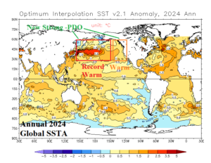
Fig. 3: The annual 2024 global SSTA analysis identifies a strong -PDO regime present (mostly) due to record warmth of the northwest/central North Pacific.
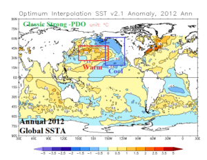
Fig. 4: A conventional strong -PDO regime present in 2012 when the Northeast Pacific was much cooler than normal.
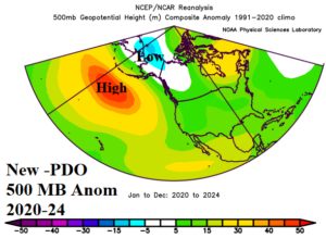
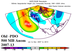
Fig. 5-6: A comparison between “new” and “old” -PDO upper air regimes.
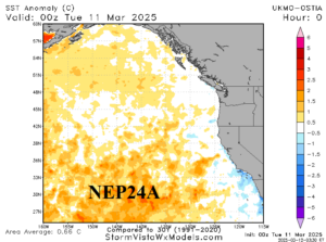
Fig. 7: The Northeast Pacific SSTA regime identifies the presence of MHW NEP24A.

