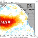
The Northeast Pacific Marine Heat Wave is Strengthening!
05/30/2024, 8:41 am EDT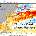
Asia Heat Spurs Increased LNG Deliveries Ahead of Summertime
05/31/2024, 8:08 am EDT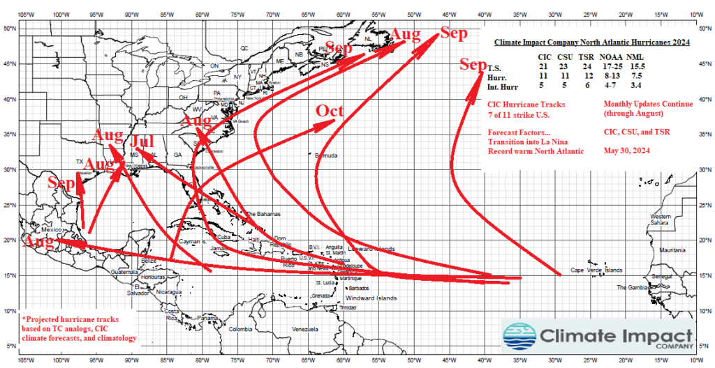
Executive summary: The Climate Impact Company North Atlantic basin seasonal activity forecast is updated. Additional updates will be issued on June 30th and July 30th. The most active part of the tropical cyclone season begins August 1st. The peak of tropical cyclone season is on September 10th. Tropical cyclone season lasts from June 1 to November 30. The latest forecast remains steady with 21 tropical storms, 11 hurricanes, and 5 major hurricanes expected. The accumulated cyclone energy (ACE) index forecast is 180. The ACE index does not have a correction bias added and could easily be over 200. The Climate Impact Company hurricane tracks forecast indicates 7 of the 11 hurricanes will strike the U.S. (Fig. 1). Several of these coastal strikes could be major hurricanes.
Fig. 1: The Climate Impact Company 2024 hurricane tracks forecast.
Forecast bias correction: Climate Impact Company North Atlantic basin seasonal forecast activity is based on a constructed analog utilizing various regional sea surface temperature anomaly (SSTA) patterns such as the El Nino southern oscillation (ENSO). The early April forecast verification yields a consistent negative (under-forecast) bias for all years (1999-2023) and years without an El Nino (Table 1). The negative bias is explained by the warming North Atlantic basin near or exceeding the ideally supportive +1.0C value during AUG/SEP/OCT in over half of the past 15 years. Also supportive of the negative forecast bias is the lack of El Nino events with only 6 of the past 24 tropical cyclone seasons experiencing warm ENSO. The non-El Nino year bias is added to the constructed analog forecast to project final seasonal totals in the latest seasonal activity projection.
| Tropical Storm Forecast Bias | Hurricane Forecast Bias | Intense Hurricane Bias | |
| 1999-2023 April Forecasts | -2.25 | -0.37 | -0.37 |
| 1999-2023 April Forecasts Non-El Nino Year | -2.89 | -0.73 | -0.26 |
Table 1: Climate Impact Company April forecast bias for all 1999-2023 North Atlantic basin seasonal tropical cyclone forecasts plus years without El Nino.
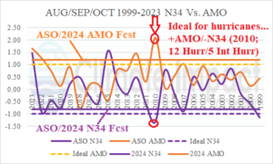
Fig. 2: The AUG/SEP/OCT 1999-2023 Nino34 SSTA and Atlantic multi-decadal oscillation.
Averaging all dynamic and statistical Nino34 SSTA forecasts, the AUG/SEP/OCT 2024 value is projected at -0.8C which is very close to the ideal Nino34 index supporting many hurricanes (Fig. 1). The North Atlantic basin SSTA identified by Atlantic multi-decadal oscillation (AMO) is forecast near +1.2C and is (also) very supportive of many hurricanes for the upcoming season. A recent example of a tropical cyclone season featuring both ideal Nino34 and +AMO patterns for hurricanes to flourish was 2010 when 12 hurricanes and 5 intense hurricanes formed.
The updated seasonal forecast: The selected analog years used to project the 2024 seasonal activity are based on very warm North Atlantic SSTA signatures and an ENSO regime shifting into La Nina. The analog years are 1995, 1998, 2007, and 2021 (Table 2). The average activity for each analog year plus the correction bias yields a seasonal forecast of 21 tropical storms, 11 hurricanes, and 5 intense hurricanes. The ACE index is 180 without a correction bias. Given a potential 7 land-falling hurricanes, the ACE index could be well above 200. In fact, given the hurricane landfall forecast, the ACE index of 227 in 1995 is reasonable. The forecast has increased intensity slightly.
| Year (weight) | Tropical Storms | Hurricanes | Intense Hurricanes | ACE Index |
| 2021 | 21 | 7 | 4 | 146 |
| 2007 | 19 | 12 | 5 | 166 |
| 1998 | 14 | 10 | 3 | 182 |
| 1995 | 19 | 11 | 5 | 227 |
| Average | 18.25 | 10.0 | 4.25 | 180.25 |
| Correction | 2.89 | 0.73 | 0.26 | N/A |
| Forecast | 21 | 11 | 5 | 180 |
| Previous | 20 | 10 | 6 | 179 |
| 5-Year NML | 20.6 | 8.2 | 3.6 | 139.8 |
| 15-Year NML | 16.9 | 7.6 | 3.4 | 132.8 |
| 30-Year NML | 15.5 | 7.5 | 3.4 | 130.4 |
Table 2: The CIC-CA North Atlantic basin 2024 seasonal tropical cyclone activity forecast.
Other seasonal forecasts: Tropical Storm Risk U.K. updated their outlook today and raised values slightly to 24 storms, 12 hurricanes, and 6 major hurricanes (Table 3). The Colorado State University (CSU) forecast is updated next week, and a slight increase is expected. The NOAA outlook is provided in ranges and projects up to 25 tropical storms, 13 hurricanes, and 7 major hurricanes. Most of these forecasts are the highest values issued for seasonal forecasts since they began back in 1984 (by Colorado State University).
| Tropical Storms | Hurricanes | Intense Hurricanes | ACE Index | |
| CIC | 20 | 10 | 5 | 187 |
| CSU | 23 | 11 | 5 | 210 |
| TSR/UK | 24 | 12 | 6 | 226 |
| NOAA | 17-25 | 8-13 | 4-7 | N/A |
Table 3: The North Atlantic basin 2024 tropical cyclone seasonal activity forecast from Climate Impact Company, Colorado State University, Tropical Storm Risk/U.K., and NOAA/NHC.
Regional forecasts: Seasonal forecasts are agreeable that activity during the 2024 season will be above to much above normal and possibly challenge a record. Implied is a dangerous several months in the U.S., Caribbean Sea, and Mexico plus Southeast Canada.
Gulf of Mexico: The Climate Impact Company hurricane tracks forecast indicates as many as 6 hurricanes with coastal strikes for Texas, Louisiana, and Florida. The outlook indicates two strikes for Louisiana and three landfalling hurricanes for Florida. Both strikes for Louisiana are in August with September strikes in Texas and southern Florida plus a Florida strike in October.
Southeast: An August and September hurricane is forecast to visit the Southeast Coast. The first is in August extending northwestward from the Bahamas while a second strikes Florida and makes a second landfall in the Carolinas in September.
Mid-Atlantic: The projected hurricane tracks show a strong northeastward bend once reaching 35N which implies storms are turning out to sea before reaching the Mid-Atlantic States north of Virginia.
Northeast: At least two close calls are forecast to occur in August and September.
Mexico: Of course, the Gulf of Mexico is busy. One storm, likely a major hurricane, forms in the Cape Verde Islands and moves across the length of the North Atlantic basin to the Yucatan Peninsula and eventually Old Mexico.
Caribbean Islands: As many as 5 or 6 tropical cyclones flirt with the Northern Caribbean Islands. At least one direct hit is forecast for Cuba, Hispaniola, and Puerto Rico.