La Nina Development Stalls
06/25/2024, 8:20 am EDTModerate Upper Shear Monitored, Possibly Inhibiting 95L Development
06/28/2024, 9:02 am EDT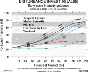
Fig. 1: Tropical cyclone models intensity forecast for 95L.
Discussion: Tropical cyclone models offer the first intimidating outlook of the 2024 season in the North Atlantic basin by indicating Tropical Disturbance 95L currently located in the outer tropical North Atlantic intensifies to a hurricane by late weekend and possibly a major hurricane in 5 days (Fig. 1). In 5 days, 95L (next storm name is Beryl) is in the eastern Caribbean Sea (Fig. 2). The extended range (day 6-10) forecast of this system is a westward low latitude track rather than turning toward the Gulf of Mexico or Coastal U.S. However, forecast confidence becomes established AFTER a system has developed AND reached tropical storm intensity.
Tropical Disturbance 94L located in the west-central Caribbean Sea tracks west-west-northwest during the next 3-5 days with limited ability to develop due to proximity to land. An ALERT is issued for a possible tropical cyclone later this weekend. If a system develops, a quick trek to inland Mexico is likely.
An excellent guide to identify the environment ahead of a developing tropical cyclone to judge whether intensification is likely (or not) is knowing the mid-level troposphere relative humidity (RH) levels. A moist (dry) atmosphere at 600 MB supports (prevents) development. The environment in the Northern Caribbean Sea to the Southern Gulf of Mexico plus Florida and the Bahamas is robust wet and indicates a ripe atmosphere supportive of tropical cyclone activity (Fig. 3).
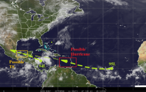
Fig. 2: Morning satellite view of the North Atlantic basin.
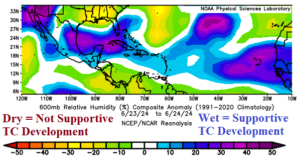
Fig. 3: 600 MB relative humidity analysis for June 23-24, 2024.