Daily Feature: The Over-achieving Sun!
09/08/2024, 9:22 am EDTThe U.S. AUG-24 and JUN/JUL/AUG-24 Verification
09/10/2024, 1:36 pm EDTHighlight: Tropical Storm Francine becomes a hurricane today and turns north and northeast to Vermillion Bay by 4PM tomorrow as a category 2 hurricane.
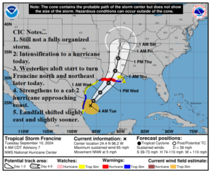
Fig. 1: Latest NOAA/NHC 5-day forecast track for Francine.
Discussion: At 5AM EDT, Tropical Storm Francine was located at 24.4N/96.2W or about 120 miles south-southeast of the mouth of the Rio Grande. Movement is north-northwest at 5 mph with top wind near 65 mph and surface pressure 992 MB. NOAA/NHC claims more organization of Francine overnight. However, satellite view reveals two sperate areas of intense weather. A large mass of thunderstorms is north of Francine in the northwest Gulf while the convection directly associated with Francine is off the Northeast Coast of Mexico. A likely cause of the separation of weather features is increasing westerly flow aloft off the Texas Coast. Consequently, Francine’s north-northwest drift is short-lived and a turn toward the north is likely today followed by a north to northeast acceleration tomorrow. The NOAA/NHC forecast track is adjusted slightly right/east at landfall to directly over Vermillion Bay around 4PM tomorrow. The intensity forecast by tropical cyclone models is a little less intense, likely biased by the lack of complete development this morning. However, NOAA/NHC takes Francine to a 100-mph full-throttle category-2 hurricane prior to landfall later tomorrow. HWRF drops surface pressure to 962 MB prior to landfall indicating a potential major category-3 hurricane. However, the model was too low with initialization pressure and that error may have increased with time during the model run. Francine crosses warm 87F/31C water today although the waters cool slightly south of Louisiana and Francine encounters strong westerly shear prior to landfall. A last-minute strengthening storm, similar to Beryl, is less likely for Francine. As Francine gains strength tomorrow, the storm will propel a pile of water northward into the Louisiana Coast. Storm surge up to 10 feet is possible along a lengthy swath of the Louisiana Coast highest where the storm moves inland and areas just to the east. Coupled with extreme rain, a life-threatening flooding condition is likely for much of Southern Louisiana. A large mass of thunderstorms ahead of Francine arrives tonight followed by Francine’s weather tomorrow in Louisiana.
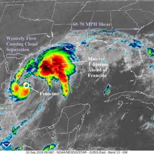
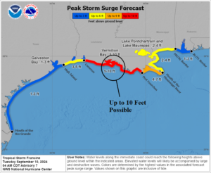
Fig. 2-3: Weather satellite view of Francine and the latest NOAA/NHC storm surge forecast.
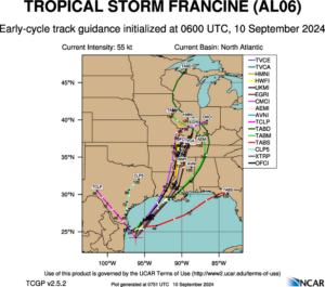
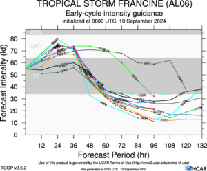
Fig. 4-5: Tropical cyclone models forecast track and intensity for Francine.
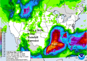
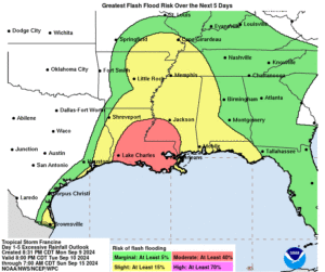
Fig. 6-7: NOAA/WPC 5-day rainfall forecast and NOAA/NHC flood risk outlook associated with Francine.
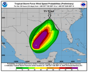
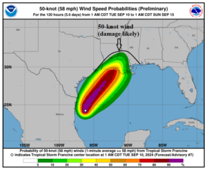
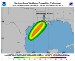
Fig. 8-10: Wind speed profile forecasts from NOAA/NHC for Francine.