-AO/-NAO Bring Autumnal Air Mass to Midwest U.S. Days 6-10
09/02/2024, 6:37 am EDTNorthern Hemisphere Snow Cover Trend During Cold Season
09/05/2024, 12:49 pm EDTHighlight: Getting ready for significant uptick in TC activity as tropical Africa becomes soaking wet and emits strong tropical waves into the Atlantic.


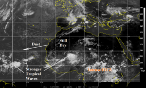
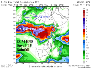
Fig. 1-2: Weather satellite view of the eastern North Atlantic tropics and tropical Africa plus the ECM ENS 15-day rainfall forecast for tropical Africa.
Discussion: The unexpected quiet period across the tropical/subtropical North Atlantic basin may be about to end. Tropical waves are stronger as they move across tropical Africa and into the eastern North Atlantic tropics (Fig. 1). However, the ECM ENS 15-day rainfall forecast indicates extreme rain across tropical Africa as tropical waves and their attendant convective energy are about to intensify dramatically (Fig. 2). Also note the still dry regime across the Sahara and dust cloud evident by the “glint” in weather satellite photos into the North Atlantic is likely to dissipate as rainfall extends to Northwest Africa through the middle third of September.
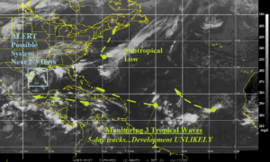
The morning North Atlantic weather satellite view indicates plenty of possible trouble but limited expectations (Fig. 3). Three tropical waves are monitored for possible development across the tropics. 5-day forecast tracks are indicated. Each system is not expected to become a tropical cyclone. An alert for low pressure hovering off the Texas Coast for a sudden tropical system is a concern the next 2-3 days and an ALERT is posted. Rainfall amount near 15 in. is forecast near the Texas Coast south of Houston. A subtropical low is forecast to form east of North Carolina and whirl northward to Nova Scotia this weekend.

Fig. 3: North Atlantic basin weather satellite view.
