The Tall Waters of the Gulf of Mexico
06/13/2024, 2:34 pm EDTNOAA Long-lead Climate Forecast Indicates Potential Ferocious Heat in the East U.S. During July
06/20/2024, 10:28 am EDT
Fig. 1: North Atlantic basin satellite view of current important features.
Discussion: The historic rainfall flooding Southern Florida during the past week is easing. “Historic” in that the extreme rain was not associated with a tropical cyclone. The low-pressure zone and wet trade winds are shifting westward this week. However, this time a tropical cyclone will enhance the rainfall and bring flooding to the northwest and west coast of the Gulf of Mexico. Currently, an area of low pressure is forming across the interior southern Yucatan Peninsula (Fig. 1). Tropical cyclone models generating forecast tracks are issued soon. The preliminary track based on a consensus between GFS and ECM is evolution of a tropical depression east or north of the Bay of Campeche early this week strengthening to a tropical storm shifting into Mexico Wednesday night. Forecast confidence increases dramatically once a system has developed. The tropical feature enhances wet trade winds to the north and according to the popular National Blend of Models (NBM) 7-day rainfall forecast, 9-11 inches of rain causing widespread flooding is expected from Northeast Mexico to Southwest Louisiana (Fig. 2).
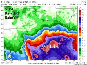
Fig. 2: NBM 7-day rainfall forecast for Texas.