The Much Warmer Than Normal Eastern Gulf of Mexico
09/23/2024, 1:49 pm EDTSharply Cooler Equatorial East Pacific Subsurface Offers La Nina Energy if Tradewinds are Sustained
09/25/2024, 10:53 am EDTHighlight: PTC Nine encountering shear. Development likely tonight/Wednesday. NOAA projects a major hurricane in the northeast Gulf. HWRF/HMON forecast category-4 major hurricane in northeast Gulf.
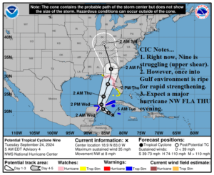
Fig. 1: Latest NOAA 5-day forecast track for Potential Tropical Cyclone Nine.
Discussion: At 5AM EDT, Potential Tropical Cyclone Nine was located at 18.9N/83.0W or about 120 miles west-southwest of Grand Cayman. PTC Nine is moving northwest at 8 mph with maximum sustained wind near 35 mph and central pressure 1001 MB. Nine remains disorganized primarily due to mid-level and high-level shear to the west and north of the system. Latent heat release from Hurricane John now moving inland on the south coast of Mexico should cause the upper low causing the shear to slow Nine’s development to dissipate within 24 hours. Meanwhile, Nine rides the southwest side of the North Atlantic subtropical ride toward the southeast Gulf of Mexico today/tonight and becomes a named storm. Once into the Gulf, a hurricane is likely. A sharp trough over the Central/East-central U.S. will capture Helene late Wednesday and guide the storm north-northeastward probably at a faster pace than most hurricanes in this location at this time of year. NOAA projects a major hurricane in the northeast Gulf of Mexico on Thursday making landfall Thursday evening on the Northwest Florida Big Bend Region. This storm will produce a major life-threatening storm surge to northwest Florida, hurricane force wind in northern and west coast Florida, extreme rain causing flooding pushing well inland to the southern Appalachians, and a swath of severe weather across Florida.
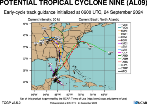
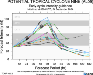
Fig. 2-3: Tropical cyclone models indicate landfall slightly west of the NOAA forecast with one model reaching category-3 major hurricane intensity.
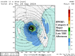
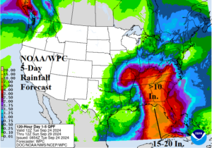
Fig. 4-5: The HWRF model takes Helene to a strong category-4 major hurricane in the northeast Gulf of Mexico just prior to landfall. The NOAA/WPC 5-day rainfall forecast indicates a massive area of extreme rain.
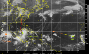
Fig. 6: Morning weather satellite view identifies the proximity of John and PTC Nine. As John weakens/shifts inland, the environment for Nine improves and allows a tropical cyclone to form (rapidly). 98L is forecast to become named storm.