
Moderate Upper Shear Monitored, Possibly Inhibiting 95L Development
06/28/2024, 9:02 am EDT
Intense Heat and Dryness Ahead for Southeast Europe to Southwest Russia
07/01/2024, 1:14 pm EDT
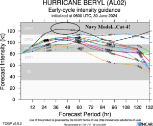
Fig. 1: Tropical cyclone models and their 5-to-6-day intensity forecasts for Major Hurricane Beryl.
Discussion: First and foremost, development of a major hurricane in the central North Atlantic tropics in late June is unprecedented and underscores the expected influence of much warmer than normal ocean temperatures on the 2024 tropical cyclone season ahead for numbers and intensity of storms.
Second, Major Hurricane Beryl is located at 10.6N/53.9W or about 420 miles east-southeast of Barbados. Beryl is moving west at 21 mph with top wind 115 mph and surface pressure 968 MB.
Third, the environment surrounding Beryl is ideal for additional intensification. The ocean surface is 29C/85F and wind shear less than 10 knots according to NOAA/NHC. Yesterday, Climate Impact Company (CIC) identified a moderate southwest shear axis across the eastern edge of the Caribbean Sea. The shear axis has weakened and lifted north of Beryl. Consequently, NOAA/NHC expects Beryl to reach category-4 intensity before reaching the Windward Islands tomorrow. The U.S. Navy model indicates category-4 intensity for 24-72 hours which is preferable for Beryl’s intensity forecast through midweek (Fig. 1). Again, this strength for this early in the season in this location is unheard of.
Finally, ECM appears to have the best handle on the long-range forecast track of Beryl keeping the system moving westward south of the powerful subtropical ridge to the north (Fig. 2). The NOAA/NHC 5-day forecast has shifted the 4-5-day track farther south into the central Yucatan Peninsula Thursday night. NOAA/NHC projects Beryl to lose major hurricane classification approaching the Yucatan Peninsula due to presence of a persistent moderate westerly shear axis in this location.

Fig. 2: ECM 8-to-9-day forecast track of Major Hurricane Beryl.