Comparing Q2/2025 and Meteorological Summer 2025 NOAA and CIC Climate Forecasts
03/20/2025, 9:28 am EDT
If Warm Nino12 SSTA Region Persists, Hurricane Activity Suppressed
03/31/2025, 1:07 pm EDT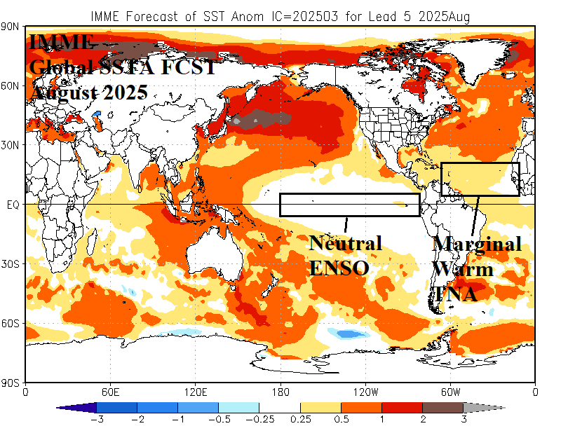
Highlight: Another active year but less active than the recent record-breaking seasons.
Executive summary: The Climate Impact Company 2025 North Atlantic basin tropical cyclone season forecast projects 17 tropical storms, 7 hurricanes, and 5 intense hurricanes. The accumulative cyclone energy (ACE) index forecast is 137. The activity forecast is near to slightly higher than the 30-year normal and slightly less active than the 2016-24 active period. The forecast is based primarily on the presence of neutral El Nino southern oscillation (ENSO) and marginally warm sea surface temperature anomalies (SSTA) in the main development region (MDR) for North Atlantic hurricanes located in-between the Caribbean Sea and northwest coast of Africa. The projected hurricane tracks for the 2025 season indicate 2 U.S. coastal strikes favoring Texas and the Carolinas. Most of the 2025 season hurricane activity occurs in September.
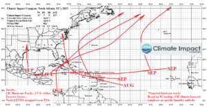
Fig. 1: The Climate Impact Company seasonal activity forecast and projected hurricane tracks for the 2025 North Atlantic basin TC season.
Climate: The (recent) climate catalysts forcing unusually high amounts of hurricanes in the North Atlantic basin is the presence of La Nina climate (as defined by multivariate ENSO index) and very warm sea SSTA in the North Atlantic tropics (as defined by tropical North Atlantic index). These conditions were especially present during 2017 (10 hurricanes/6 major hurricanes), 2020 (13/6), and 2024 (11/5). A La Nina climate produces below normal wind shear aloft necessary across the North Atlantic tropics to allow abundant tropical cyclones to form and storm intensity increases due to the anomalous warm ocean.
The Climate Impact Company (CIC) multivariate ENSO index (MEI) projection for the 2025 tropical cyclone season is based on specific analog years matching the past 12 months and projected forward through December. The analog forecast indicates neutral MEI for the tropical cyclone season with a range favoring borderline La Nina to the outlier weak El Nino (Fig. 2). The tropical North Atlantic (TNA) index is calculated in the MDR for hurricanes located in-between the Caribbean Sea and the northwest Africa coastline. Using a similar forecast technique, the CIC TNA index projection for the 2025 tropical cyclone season is for marginal warm phase, somewhat less warm than the most active (recent) hurricane years (Fig. 3).
The global SSTA forecast valid for August 2025, as the most active part of the season begins, by the International Multi-modal Ensemble (IMME) confirms the analog forecast indicating neutral ENSO and marginal warm TNA index (Fig. 4). Compared to last August, the eastern equatorial Pacific is not as cool and the MDR is not as warm (Fig. 5).
Last year, a major drought was present across much of North and West Africa (Fig. 6). Seasonally strong mid-summer trade winds picked up dust from the West Africa drought and swept the particulates across the tropical/subtropical central and east North Atlantic basin to stabilize the low-level environment and cause a temporary stalling of tropical cyclone activity during the late calendar summer. Currently, the West Africa drought is (mostly) eliminated (Fig. 7).
Notable during the most active (recent) hurricane years is the presence of a persistent phase_2 and phase_3 of the Madden Julian oscillation (MJO). The convection phase of the MJO located in P2/P3 (tropical east Africa into the Indian Ocean) enables unusually intense tropical waves to form, some of which shift westward into the eastern tropical North Atlantic. These tropical waves contain abundant potential energy enabling increased risk of tropical cyclone development. The MJO was unusually active during the weak La Nina of late 2024/early 2025. This condition is forecast to continue through the spring season. Based on the activeness of the current MJO regime, a persistent P2/P3 MJO during the 2025 tropical cyclone season is less likely to occur as observed during the active hurricane years of 2017 and especially 2020 and 2024.
The prevailing upper air pattern during the 2016-2024 active tropical cyclone pattern across the North Atlantic basin has featured a 500 MB anomaly pattern yielding a persistent upper-level high-pressure ridge across Quebec (Fig. 8). South of the Quebec upper ridge, the steering currents have a stronger than normal east-to-west component increasing the risk of U.S. coastal strikes during the 9-year active pattern. The projected 500 MB pattern for AUG/SEP/OCT 2025 maintains the Quebec upper ridge bias (Fig. 9). However, two upper-level low-pressure areas are (also) indicated, over Kentucky and the Azores. Presence of each upper trough produces an area of westerly shear across the Southeast U.S. and in the outer tropics inhibiting tropical cyclone development. Finally, mid-level troposphere wet specific humidity anomalies identify areas where tropical cyclone activity is most likely to flourish. The outlook is wetter than normal and supportive of development and intensification across the northern Caribbean Islands and northward to the east of the Bahamas (Fig. 10).
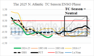
Fig. 2: Climate Impact Company analog forecast of the multi-variate ENSO index favors neutral phase.
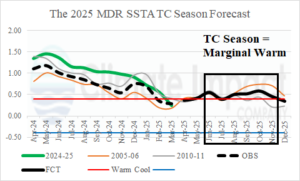
Fig. 3: Climate Impact Company analog forecast of the tropical North Atlantic index located in the main development region for North Atlantic hurricanes indicates marginal warm phase.
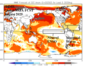
Fig. 4: The International Multi-modal Ensemble global SSTA forecast valid for August 2025 reveals neutral ENSO and marginally warm waters in the tropical North Atlantic.
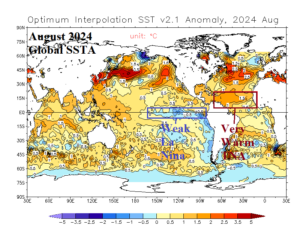
Fig. 5: The August 2024 global SSTA analysis identifying borderline cool conditions in the eastern equatorial Pacific and very warm waters in the North Atlantic tropics.
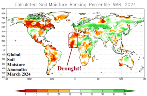
Fig. 6: The global soil moisture anomalies analysis for one year ago reveals a large drought across North and West Africa.
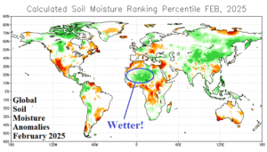
Fig. 7: The most recent (monthly) global soil moisture anomalies analysis reveals last year’s drought across North and West Africa is greatly diminished.
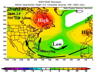
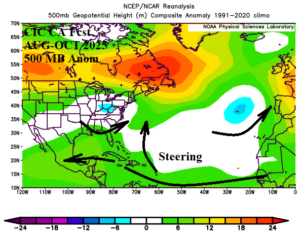
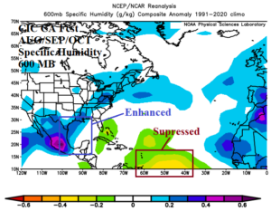
Fig. 8-10: The prevailing 500 MB anomaly pattern across the North Atlantic basin during the 2016-24 active period focused on AUG/SEP/OCT, the projection 2025, and the specific-humidity anomaly projection for that same timeframe.
The 2025 season predictors: The outlook is primarily focused on ENSO and TNA analog years. The tendency to under-forecast seasonal activity during the 2016-24 active period has produced a forecast bias, most evident in tropical storm numbers, which is added to the analog projection. The hurricane track projections are based primarily on the specific humidity projections combining both the tropical cyclone analog years and the conventional CIC-CA climate forecast analog years.
The 2025 season analog forecast: The 2025 North Atlantic basin tropical cyclone season activity forecast projects 17 tropical storms, 7 hurricanes, and 5 major hurricanes (Table 1). The accumulated cyclone energy (ACE) index is 137. The seasonal activity forecast is close to the 15-year normal. A total of 2 tropical cyclones are likely to make landfall in the U.S. this season.
| Weight | Tropical Storms | Hurricanes | Major Hurricanes | ACE Index | Coastal Strikes | |
| 1996 | 1 | 13 | 9 | 6 | 166 | 4 |
| 2006 | 2 | 10 | 5 | 2 | 83 | 3 |
| 2011 | 1 | 19 | 7 | 4 | 126 | 3 |
| 2017 | 1 | 17 | 10 | 6 | 225 | 5 |
| Average | 13.8 | 7.2 | 4.0 | 136.6 | 3.75 | |
| Bias | +3.6 | 0.0 | +0.6 | |||
| Total | 17.4 | 7.2 | 4.6 | 136.6 | 3.75 | |
| Forecast | 17 | 7 | 5 | 137 | *2 | |
| 15-Year | 17.9 | 8.1 | 3.5 | 133.6 | ||
| 30-Year | 15.9 | 7.8 | 3.5 | 134.8 | ||
| 50-Year | 13.2 | 6.7 | 2.8 | 108.8 | ||
| 2016-24 | 18.8 | 8.6 | 3.9 | 151.1 |
Table 1: The Climate Impact Company constructed analog forecast for 2025 North Atlantic basin tropical cyclone season activity. *Due to upper shear CIC cuts back the number of coastal strikes from 4 to 2.
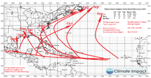
The 2025 season projected hurricane tracks: The seasonal outlook projects 7 hurricanes. The hurricane track projections (Fig. 11) are heavily weighted by the mid-troposphere specific humidity forecast. The outlook indicates a zone of high activity across the northern Caribbean Islands and north to northeastward from that location. Two hurricane strikes are indicated to the U.S. Coast. A locally generated hurricane in the western Gulf of Mexico moves into Texas in September and a long-distance traveler from the outer tropics moves through the Caribbean Islands and north and northwestward to the Carolinas in September. Two hurricanes are born in the outer North Atlantic tropics, one turning northward immediately and a second traveling across the length of the tropical basin to Belize. Both systems generate in September. The majority of 2025 hurricanes occur in September.
Fig. 11: The Climate Impact Company projected hurricane tracks for the 2025 season.
Other forecasts: The 2025 North Atlantic basin tropical cyclone season activity forecast from Colorado State University is scheduled for April 7 release. The Tropical Storm Risk/U.K. seasonal forecast is scheduled for April 3. NOAA/NHC releases their seasonal outlook just prior to the onset of the season in late May. CIC projects a similar forecast, slightly more active than normal but less active than the most active recent years.
Forecast summary: The Climate Impact Company 2025 North Atlantic basin tropical cyclone season will maintain the 2016-24 active period. However, the 2025 forecast is slightly below the 2016-24 average activity except for the number of intense hurricanes. The forecast is slightly above the longer-term climatology. Key to the forecast is the marginal warmth forecast in the MDR, somewhat cooler than much of this decade. Upper ocean heat is near to above normal but somewhat less than recent years especially in the MDR. Consequently, seasonal activity, while still impressive, is held back slightly. Areas of anomalous warm water are forecast for the Caribbean Sea, the Bahamas, and Gulf of Mexico. Tropical cyclones tracking into these basins will have the chance to become major hurricanes mostly in September. The forecast projects 2 coastal hurricane strikes (Texas and the Carolinas) although the analog indicates up to 4 coastal strikes are possible. Above normal upper westerly shear near the U.S. Coast is projected therefore the coastal strike risk for hurricanes is cut back. The ENSO forecast for the 2025 tropical cyclone season is neutral phase which is supportive of above normal tropical cyclone activity. Forecast confidence on ENSO phase is below average for the late tropical cyclone season. The next update of the Climate Impact Company 2025 North Atlantic basin seasonal tropical cyclone forecast is in late May. Other forecasters, such as Colorado State University and Tropical Storm Risk U.K., issue forecasts in early April and should be very close to the 17/7/5 outlook by CIC.
Appendix
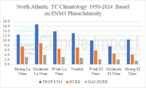
Appendix 1: North Atlantic tropical cyclone activity according to phase of El Nino southern oscillation. A neutral phase is forecast for 2025.
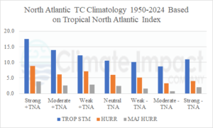
Appendix 2: North Atlantic tropical cyclone activity according to phase of tropical North Atlantic index. Weak +TNA is forecast for 2025.
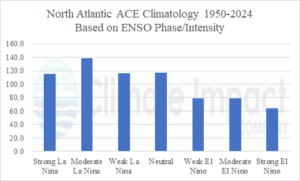
Appendix 3: North Atlantic ACE index according to phase of El Nino southern oscillation.
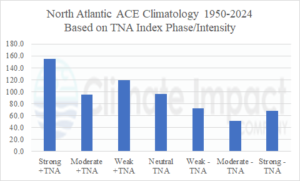
Appendix 4: North Atlantic ACE index according to phase of tropical North Atlantic index.
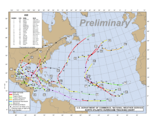
Appendix 5: The Climate Impact Company projected hurricane tracks for the 2024 season.
Appendix 6: Verification of North Atlantic basin tropical cyclones in 2024.