Potential Regenerating Cold in the Northeast U.S. Early January
12/02/2024, 8:00 am ESTGlobal Soil Moisture 3-Month Trend Report
12/05/2024, 8:43 am EST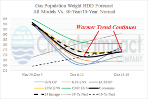
Fig. 1: U.S. gas population weight HDD forecast warms to the 10-year normal next week (and the following week) as the current cold rapidly departs.
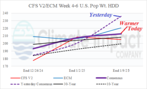
Fig. 2: In the extended range, the U.S. gas population weight HDD forecast based on CFS/ECM consensus shifts warmer during January 3-9.
Discussion: The U.S. population weight HDD forecasts indicate the short-term cold in the East is gone rapidly next week as the entire U.S. shifts warmer (Fig. 1). The warmth continues into the following week. The extended range HDD forecast by CFS V2 and ECM indicates a consensus that cools the U.S. to in-between the 30-year and 10-year normal Dec. 20-26 with additional cooling to near the 30-year normal into early January (Fig. 2). A polar chill returns but arctic air is not present. The CFS V2/ECM consensus forecast for Jan. 3-9 is somewhat warmer than yesterday.
A look at the primary climate controllers through the middle third of December yields an active and moderate to strong Madden Julian oscillation (MJO) across Maritime Continent. MJO phase_5 (Fig. 3) has a strong warming influence on the U.S. climate (Fig. 4) which is in the current medium-range forecast.
In the 16-30-day period (Fig. 5), ECMWF indicates MJO shifts east and slowly weakens moving toward the Dateline (phase_6 and phase_7). During that transition, the influence of MJO on U.S. climate shifts from warm to cooler (Fig. 6). The MJO phase_7 is weak therefore the cool climatology is too strong.
Regarding the stratosphere, the outlook is cold in the upper atmosphere across North America for much of December which enhances the returning warm pattern. However, by mid-month, there is stratospheric warming indicated over Asia (Fig. 7) which could lead to the evolution of a polar vortex in the 11-15-day period across Western Russia (Fig. 8). A shift of stratospheric warming to North America and the polar region later this month or early January is possible but not indicated for now.
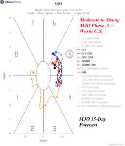
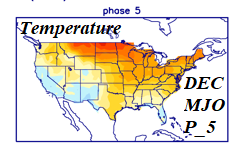
Fig. 3-4: The 15-day Madden Julian oscillation forecast indicates moderate to strong intensity in phase_5 (Maritime Continent) which is a warming influence on the U.S. in December.
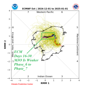
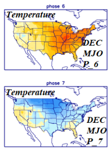
Fig. 5-6: The ECMWF extended range (days 16-30) MJO forecast indicates weakening and a shift from phase_6 to phase_7 (across the Pacific). Once reaching phase_7, the U.S. usually begins to cool.
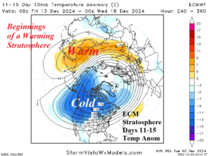
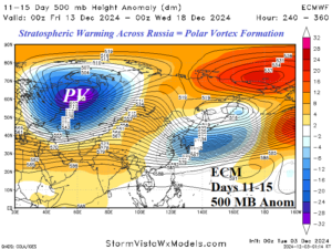
Fig. 7-8: Hints of stratospheric warming appear in Asia in the 11-15-day period leading to a polar vortex risk across Eurasia in Mid-December.
