August 2024 Marine Heatwave Report
08/20/2024, 8:42 am EDTUPDATED North Atlantic Basin 2024 Tropical Season Outlook…Still Very Active SEP/OCT/NOV
08/27/2024, 8:04 am EDT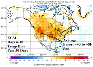
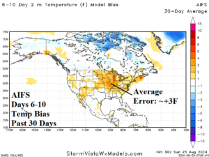
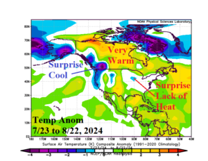
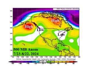
Fig. 1-4: The ECM and AIFS temperature forecast bias for the 6-10-day period from the past 30 days (upper) and 30-day North America temperature anomalies and 500 MB anomaly verification (lower).
Discussion: Summer 2024 has produced forecast problems at the medium range and seasonal level. The seasonal tropical cyclone forecast is apparently much too active, and U.S. medium range forecasts have been too warm. In this report, a discussion regarding the 6-10-day forecast temperature bias.
ALL models have been too warm. The normally most reliable model, ECM, has featured +3F to +5F forecast bias across the Northwest U.S. and central Great Plains (Fig. 1). The newly implemented AIFS forecast bias is somewhat less bold averaging +3F in the Midwest U.S. (Fig. 2). Likely demonstrated here is AIFS learning the model bias and applying the correction to the forecast.
The sensible weather during the 30-day period evaluated has featured sneaky cool temperatures in Southwest Canada/Coastal Northwest U.S. and a surprising lack of important heat in the Midwest States to the Mid-Atlantic Coast, a key zone to the U.S. energy grid (Fig. 3). The cooler than expected temperatures are caused by the presence of an upper trough centered on Seattle, WA and a broad upper trough centered on Richmond, VA (Fig. 4). Each feature was not forecast by seasonal predictions.
The most interesting feature is the East Coast trough directly correlated to unexpected cooling of the western North Atlantic basin. This oceanic zone was record warm a few months ago but during summer has steadily cooled to near normal with dramatic cooling over the past 30 days (Fig. 5-6). Large regions of cooling SSTA usually occur beneath upper troughs.
In the Northeast Pacific, a marine heat wave (MHW) strengthened and shifted eastward to the U.S. West Coast during early summer causal to the first half of summer heat waves in California to the Northwest States. But during the past several weeks the MHW has weakened (Fig. 7-8) and the Northwest U.S. trough formed.
Dynamic models, such as ECM, were expecting a warmer surface leading to stronger high pressure aloft causing hotter sensible weather which dries soils. The feedback to the atmosphere of hotter weather/drier soils resonates into the medium range which is usually the correct process for summertime weather. However, in this case, the usual process created moderate to large errors in U.S. medium range forecasts.
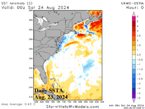
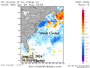
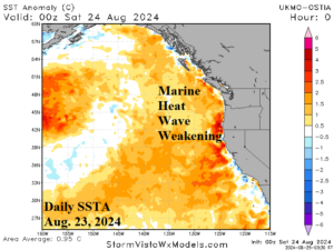
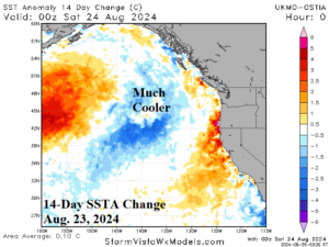
Fig. 5-8: Western North Atlantic basin sea surface temperature anomalies (SSTA) and the 30-day change (upper) and Northeast Pacific SSTA and 14-day change.