New Vs. Old Pacific Decadal Oscillation
03/14/2025, 3:40 pm EDT
Comparing Q2/2025 and Meteorological Summer 2025 NOAA and CIC Climate Forecasts
03/20/2025, 9:28 am EDT 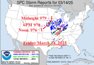
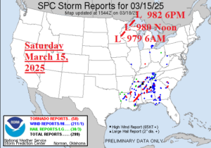
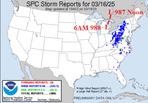
Fig. 1-3: Unusually low pressure fueled the March 16-18 severe weather outbreak.
Discussion: Unusually low pressure fueled a severe weather episode, beginning last Friday (Mar. 14) and continuing through the weekend (Mar. 15-16). On Friday, the storm center travelled northeastward from southwest Kansas to southern Minnesota with surface pressure between 976 and 979 MB. On Friday, streaks of hostile weather were observed from Kansas City to Chicago, St. Louis to Dayton, and near Little Rock to Cincinnati (Fig. 1). Nearly 1,000 severe weather reports were generated by the high impactful weather on Friday. The severe weather folded southeastward and into the Southeast States on Saturday diminished in size but not intensity (Fig. 2) as another 58 tornado reports were issued (after 81 on Friday). On Friday, the primary storm moved northeastward into Ontario as a 980 MB low pressure area. On Sunday, a secondary low pressure developed and gradually developed into a 987 MB low in southern Ontario by Noon on Sunday (Fig. 3). The new low-pressure area caused a massive amount of concentrated damaging wind reports centered on the western half of Pennsylvania. The 3-day storm report total was 1,746 including 148 tornado reports (Table 11).
| Hail Reports | Wind Reports | Tornado Reports | |
| Fri. Mar. 14, 2025 | 309 | 567 | 81 |
| Sat. Mar. 15, 2025 | 30 | 211 | 58 |
| Sun. Mar. 16, 2025 | 36 | 435 | 9 |
| Total | 385 | 1213 | 148 |
Table 1: The NOAA/SPC severe weather reports for the March 14-16 severe weather event.

