Dramatic Uptick in Tropical Activity Late August into Mid-September
08/14/2024, 11:47 am EDTMadden Julian Oscillation Reactivates; Suppresses North Atlantic Tropics
08/19/2024, 8:45 am EDT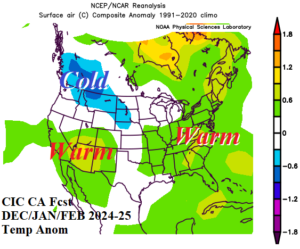
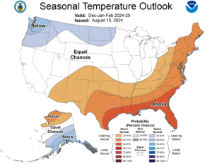
Fig. 1-2: A comparison between the Climate Impact Company constructed analog temperature anomaly forecast for DEC/JAN/FEB 2024-25 and the probabilistic outlook just released from NOAA/CPC.
Discussion: Earlier today Climate Impact Company issued a report on the projected monthly upper air pattern for winter 2024-25. The temperature anomaly pattern for DEC/JAN/FEB 2024-25, based on the upper air projections, is chilly Northwest U.S. and warmer than normal in the Southwest, Southeast, and East U.S. (Fig. 1). Not an accident is the similarity between the just issued NOAA/CPC winter temperature outlook (Fig. 2) with the CIC-CA version. The NOAA/CPC forecast process also (heavily) considers optimum climate normal (OCN) and ENSO. Precipitation forecasts are more difficult, have larger errors, and can vary in appearance when compared to other sources. However, thematically, similarity should be apparent. The CIC-CA precipitation outlook for winter 2024-25 projects heavy precipitation across Northern California and the Northwest U.S., above normal snowfall in the Upper Midwest, and dryness in the Mid-south and Southeast States (Fig. 3). The NOAA/CPC probabilistic outlook indicates above normal precipitation risk in the Northwest and Midwest States while the entire Southern U.S. is drier than normal (Fig. 4).
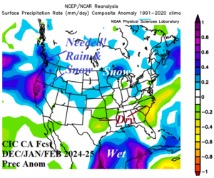
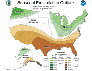
Fig. 3-4: A comparison between the Climate Impact Company constructed analog precipitation anomaly forecast for DEC/JAN/FEB 2024-25 and the probabilistic outlook just released from NOAA/CPC.
The NOAA/CPC SEP/OCT/NOV 2024 probabilistic temperature and precipitation outlook is important (Fig. 5-6). First, a major drought unfolds across the Interior West due to persistent anomalous warmth and dryness. Second, the wet projection on the East Coast to Gulf Coast and especially in Florida identifies potential land-falling tropical cyclone risk areas.
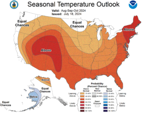
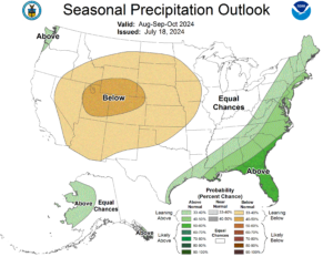
Fig. 5-6: The NOAA/CPC SEP/OCT/NOV 2024 probabilistic temperature and precipitation outlook.
The NOAA/CPC Seasonal Drought Outlook indicates the West-central U.S. drought expands across the central Great Plains to the Mid-south U.S. (Fig. 7).
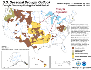
Fig. 7: The U.S. Seasonal Drought Outlook from NOAA/CPC.