Very Warm Northeast Gulf of Mexico; HWRF Forecasts a Hurricane
08/01/2024, 5:21 pm EDT
Not Much Support for La Nina Development
08/05/2024, 3:14 pm EDT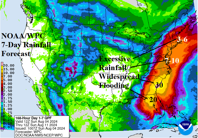
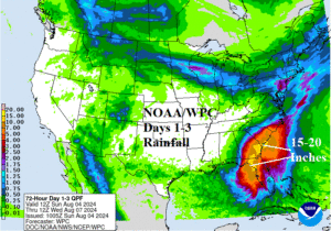
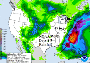
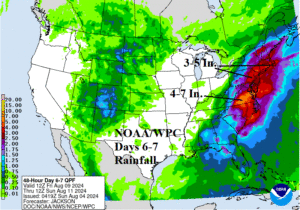
Fig. 1-3: The NOAA/WPC quantitative precipitation forecast for SUN/MON/TUE, WED-THU, and next FRI-SAT indicating an immense East U.S. rainstorm.
Discussion: Debby will become a strong category-1 hurricane making landfall tomorrow in Florida’s “Big Bend” region along the northwest coast. The storm is intensifying at landfall therefore remains a hurricane for an unusual distance after going inland. Debby slows down over the Southeast U.S. midweek over Georgia maintaining tropical storm intensity. The 72-hour rainfall forecast indicates a large area of 15-20 in. of rain across Northern Florida where Debby goes inland and across Eastern Georgia to southwest South Carolina where Debby stalls Monday night through Tuesday night (Fig. 1). An immense flooding event unfolds. Debby may drift offshore and regain some strength Wednesday night/Thursday. Forecast confidence on the mid-to-late week track is LOW. Nevertheless, Debby remains a slow-moving extreme rain producer WED-THU unloading an additional 15 in. of rain near the GA/SC coastal border with 5-10 in. of rain for the remainder of South Carolina (Fig. 2). Debby merges with an upper trough during this time causing the expanse of the heavy rain area to reach the Northeast Corridor, heaviest along the coast. The FRI-SAT forecast indicates the upper trough entraining the tropical energy from Debby continues causing excessive rainfall and flooding from Virginia to New England on FRI-SAT (Fig. 3). The 7-day total, according to NOAA/WPC, exceeds 20 in. of rain where Debby goes ashore, 30+ in. where Debby stalls over the Southeast U.S. Coast, and up to 10 in. across the Mid-Atlantic region and 3-6 in. in New England where Debby slowly merges with an upper trough (Fig. 4).

Fig. 4: NOAA/WPC 7-day rainfall forecast projects a major Southeast/East U.S. flooding episode.