Upper Ocean Heat Diminishing in The Equatorial East Pacific
11/25/2024, 11:28 am ESTWet Pattern in Brazil Continues; Shifts South
11/27/2024, 10:34 am EST 


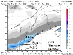
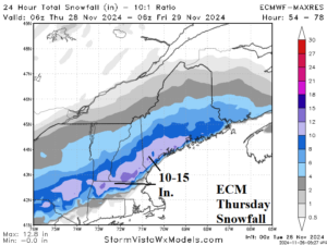
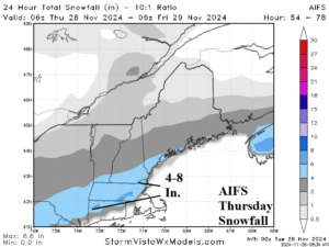
Fig. 1-3: Comparison of Thanksgiving Day forecasts of snowfall across New England by GFS, ECM, and AIFS.
Discussion: An early season exercise in snowfall forecasting is offered by the emerging colder weather pattern shifting into the East and the interpretation by the GFS, ECM, and AIFS. Thanksgiving Day looks snowy as cold air filtering into a frontal zone stretched across central and southern New England yields a swath of day-long snow accumulating to 4-8 in. according to GFS (Fig. 1). Of late, the ECM is very “dynamic” possibly over-emphasizing storm elements and having tendency to offer extreme solutions. On Thursday, ECM projects 10-15 in. of snow north of the frontal zone, much more than GFS (Fig. 2). NOAA indicates 0.50 to 0.75 in. of liquid equivalent for the snow area on Thursday with marginal temperatures supporting the lower snowfall amounts. If a much colder air mass were developing, ECM would be favored. AIFS confirms the GFS solution with a general 4-8 in. snowfall forecast (Fig. 3). Each model is a little farther south than NOAA/WPC forecasts. Of course, the new snow cover helps the increase the intensity of the following cold air mass.
