Europe Cold and Snow Ahead!
11/15/2024, 11:31 am ESTMJO-inspired Drier Brazil Climate into Middle December
11/18/2024, 5:40 am EST 


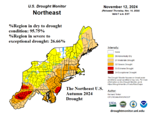
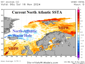
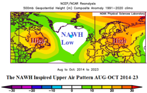
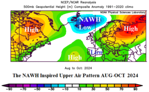
Fig. 1-4: The NOAA/USDA Northeast U.S. drought monitor, daily Northern North Atlantic SSTA, AUG-OCT 2023-24 500 MB anomalies, and OCT 2024 500 MB anomalies.
Discussion: The historical autumn 2024 drought across the Northeast U.S. was inevitable (Fig. 1). Not new, but accelerating in presence and persistence, is the North Atlantic warm hole (NAWH). NAWH is a large pool of stratified cool water usually south or southeast of Greenland caused by the increasing speed of springtime ice sheet melting from Greenland running off into the North Atlantic in a zone surrounded by the warmer than normal waters of the North Atlantic basin of the past several decades. The NAWH shifted to waters either side of Iceland during the warm season of 2024 (Fig. 2). The persistence of this feature has contributed to the shape of the late summer to mid-autumn upper air pattern across Eastern North America to Western Russia. On average, during AUG-OCT of the past 10 years, the cool atmosphere above the NAWH inspires a semi-permanent upper trough compensated for by upper-level high-pressure ridge areas in Quebec and Southwest Russia (Fig. 3). This year’s version of the NAWH low-pressure area is stronger and centered on Iceland with compensating increased strength of the Quebec and Western Russia high pressure zones (Fig. 4). The stronger NAWH low/Quebec high has increased subsidence in the upper atmosphere to dry-out the Northeast U.S. The stronger NAWH low-pressure has caused a much wetter than normal summer climate across parts of Europe while the downstream compensating high pressure caused another Western Russia drought. Note the residual low pressure over Eastern Spain with enhanced rain producing capability due to low atmosphere increased moisture made available by marine heatwaves southwest of Europe and across the Mediterranean Sea.
